You are here: Home > Network List > TA - USArray Transportable Network (new EarthScope stations) Stations List
> Station R33M Jennings River, BC, CAN > Earthquake Result Viewer
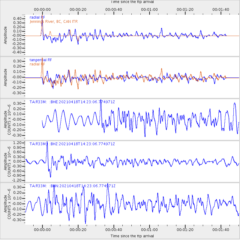
R33M Jennings River, BC, CAN - Earthquake Result Viewer
*The percent match for this event was below the threshold and hence no stack was calculated.
| Earthquake location: |
Taiwan |
| Earthquake latitude/longitude: |
23.8/121.6 |
| Earthquake time(UTC): |
2021/04/18 (108) 14:11:38 GMT |
| Earthquake Depth: |
10 km |
| Earthquake Magnitude: |
5.9 mb |
| Earthquake Catalog/Contributor: |
NEIC PDE/us |
|
| Network: |
TA USArray Transportable Network (new EarthScope stations) |
| Station: |
R33M Jennings River, BC, CAN |
| Lat/Lon: |
59.39 N/130.97 W |
| Elevation: |
1437 m |
|
| Distance: |
78.2 deg |
| Az: |
29.904 deg |
| Baz: |
296.808 deg |
| Ray Param: |
$rayparam |
*The percent match for this event was below the threshold and hence was not used in the summary stack. |
|
| Radial Match: |
64.720116 % |
| Radial Bump: |
400 |
| Transverse Match: |
55.32261 % |
| Transverse Bump: |
390 |
| SOD ConfigId: |
24334971 |
| Insert Time: |
2021-05-02 14:30:31.554 +0000 |
| GWidth: |
2.5 |
| Max Bumps: |
400 |
| Tol: |
0.001 |
|
Signal To Noise
| Channel | StoN | STA | LTA |
| TA:R33M: :BHZ:20210418T14:23:06.774971Z | 3.726292 | 5.270552E-7 | 1.4144227E-7 |
| TA:R33M: :BHN:20210418T14:23:06.774971Z | 0.9967248 | 1.3131866E-7 | 1.3175017E-7 |
| TA:R33M: :BHE:20210418T14:23:06.774971Z | 1.514575 | 1.5356802E-7 | 1.01393475E-7 |
| Arrivals |
| Ps | |
| PpPs | |
| PsPs/PpSs | |


