You are here: Home > Network List > IW - Intermountain West Stations List
> Station REDW Red Top Meadow, Wyoming, USA > Earthquake Result Viewer
REDW Red Top Meadow, Wyoming, USA - Earthquake Result Viewer
| Earthquake location: |
North Of Honduras |
| Earthquake latitude/longitude: |
16.7/-86.2 |
| Earthquake time(UTC): |
2009/05/28 (148) 08:24:45 GMT |
| Earthquake Depth: |
10 km |
| Earthquake Magnitude: |
6.7 MB, 7.2 MS, 7.3 MW, 7.3 MW |
| Earthquake Catalog/Contributor: |
WHDF/NEIC |
|
| Network: |
IW Intermountain West |
| Station: |
REDW Red Top Meadow, Wyoming, USA |
| Lat/Lon: |
43.36 N/110.85 W |
| Elevation: |
2192 m |
|
| Distance: |
33.8 deg |
| Az: |
326.898 deg |
| Baz: |
134.147 deg |
| Ray Param: |
0.07804014 |
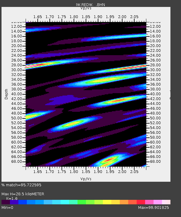
| Estimated Moho Depth: |
28.5 km |
| Estimated Crust Vp/Vs: |
1.60 |
| Assumed Crust Vp: |
6.207 km/s |
| Estimated Crust Vs: |
3.879 km/s |
| Estimated Crust Poisson's Ratio: |
0.18 |
|
| Radial Match: |
95.722595 % |
| Radial Bump: |
400 |
| Transverse Match: |
90.06914 % |
| Transverse Bump: |
400 |
| SOD ConfigId: |
2648 |
| Insert Time: |
2010-03-09 07:27:57.335 +0000 |
| GWidth: |
2.5 |
| Max Bumps: |
400 |
| Tol: |
0.001 |
|

Signal To Noise
| Channel | StoN | STA | LTA |
| IW:REDW: :BHN:20090528T08:30:56.414015Z | 21.64992 | 2.2642753E-8 | 1.0458585E-9 |
| IW:REDW: :BHE:20090528T08:30:56.414015Z | 13.749492 | 8.465035E-7 | 6.156617E-8 |
| IW:REDW: :BHZ:20090528T08:30:56.414015Z | 15.628314 | 7.7910494E-7 | 4.9852144E-8 |
| Arrivals |
| Ps | 3.0 SECOND |
| PpPs | 11 SECOND |
| PsPs/PpSs | 14 SECOND |


