You are here: Home > Network List > IW - Intermountain West Stations List
> Station REDW Red Top Meadow, Wyoming, USA > Earthquake Result Viewer
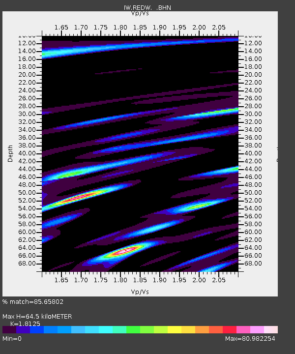
REDW Red Top Meadow, Wyoming, USA - Earthquake Result Viewer
| Earthquake location: |
Northern Mid-Atlantic Ridge |
| Earthquake latitude/longitude: |
23.9/-46.1 |
| Earthquake time(UTC): |
2009/06/06 (157) 20:33:28 GMT |
| Earthquake Depth: |
14 km |
| Earthquake Magnitude: |
6.0 MB, 5.7 MS, 6.0 MW, 6.0 MW |
| Earthquake Catalog/Contributor: |
WHDF/NEIC |
|
| Network: |
IW Intermountain West |
| Station: |
REDW Red Top Meadow, Wyoming, USA |
| Lat/Lon: |
43.36 N/110.85 W |
| Elevation: |
2192 m |
|
| Distance: |
55.9 deg |
| Az: |
307.228 deg |
| Baz: |
88.189 deg |
| Ray Param: |
0.06445833 |
| Estimated Moho Depth: |
64.5 km |
| Estimated Crust Vp/Vs: |
1.81 |
| Assumed Crust Vp: |
6.207 km/s |
| Estimated Crust Vs: |
3.424 km/s |
| Estimated Crust Poisson's Ratio: |
0.28 |
|
| Radial Match: |
85.65802 % |
| Radial Bump: |
400 |
| Transverse Match: |
66.82403 % |
| Transverse Bump: |
400 |
| SOD ConfigId: |
2648 |
| Insert Time: |
2010-03-09 07:27:59.638 +0000 |
| GWidth: |
2.5 |
| Max Bumps: |
400 |
| Tol: |
0.001 |
|

Signal To Noise
| Channel | StoN | STA | LTA |
| IW:REDW: :BHN:20090606T20:42:35.314009Z | 6.678657 | 5.5962706E-9 | 8.3793356E-10 |
| IW:REDW: :BHE:20090606T20:42:35.314009Z | 0.9330253 | 1.0403673E-7 | 1.11504725E-7 |
| IW:REDW: :BHZ:20090606T20:42:35.314009Z | 2.9362378 | 1.7799788E-7 | 6.062107E-8 |
| Arrivals |
| Ps | 8.8 SECOND |
| PpPs | 28 SECOND |
| PsPs/PpSs | 37 SECOND |


