You are here: Home > Network List > IW - Intermountain West Stations List
> Station REDW Red Top Meadow, Wyoming, USA > Earthquake Result Viewer
REDW Red Top Meadow, Wyoming, USA - Earthquake Result Viewer
| Earthquake location: |
Andreanof Islands, Aleutian Is. |
| Earthquake latitude/longitude: |
51.9/-177.5 |
| Earthquake time(UTC): |
2008/05/02 (123) 01:33:37 GMT |
| Earthquake Depth: |
14 km |
| Earthquake Magnitude: |
6.3 MB, 6.8 MS, 6.6 MW, 6.6 MW |
| Earthquake Catalog/Contributor: |
WHDF/NEIC |
|
| Network: |
IW Intermountain West |
| Station: |
REDW Red Top Meadow, Wyoming, USA |
| Lat/Lon: |
43.36 N/110.85 W |
| Elevation: |
2192 m |
|
| Distance: |
44.3 deg |
| Az: |
73.553 deg |
| Baz: |
305.369 deg |
| Ray Param: |
0.07199705 |
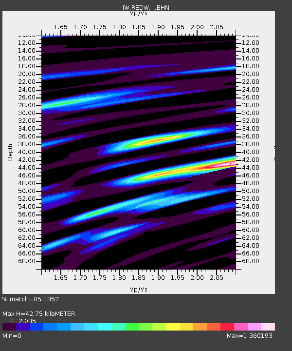
| Estimated Moho Depth: |
42.75 km |
| Estimated Crust Vp/Vs: |
2.09 |
| Assumed Crust Vp: |
6.207 km/s |
| Estimated Crust Vs: |
2.977 km/s |
| Estimated Crust Poisson's Ratio: |
0.35 |
|
| Radial Match: |
85.1852 % |
| Radial Bump: |
400 |
| Transverse Match: |
70.84514 % |
| Transverse Bump: |
400 |
| SOD ConfigId: |
2504 |
| Insert Time: |
2010-03-09 07:28:17.841 +0000 |
| GWidth: |
2.5 |
| Max Bumps: |
400 |
| Tol: |
0.001 |
|

Signal To Noise
| Channel | StoN | STA | LTA |
| IW:REDW: :BHN:20080502T01:41:15.513987Z | 7.2144217 | 6.9406775E-7 | 9.620559E-8 |
| IW:REDW: :BHE:20080502T01:41:15.513987Z | 2.915317 | 2.3796088E-7 | 8.162436E-8 |
| IW:REDW: :BHZ:20080502T01:41:15.513987Z | 1.4226604 | 2.1953407E-7 | 1.5431235E-7 |
| Arrivals |
| Ps | 7.9 SECOND |
| PpPs | 20 SECOND |
| PsPs/PpSs | 28 SECOND |


