You are here: Home > Network List > AK - Alaska Regional Network Stations List
> Station MDM Murphy Dome > Earthquake Result Viewer
MDM Murphy Dome - Earthquake Result Viewer
| Earthquake location: |
Taiwan |
| Earthquake latitude/longitude: |
23.9/121.5 |
| Earthquake time(UTC): |
2021/04/18 (108) 14:14:36 GMT |
| Earthquake Depth: |
10 km |
| Earthquake Magnitude: |
5.8 mww |
| Earthquake Catalog/Contributor: |
NEIC PDE/us |
|
| Network: |
AK Alaska Regional Network |
| Station: |
MDM Murphy Dome |
| Lat/Lon: |
64.96 N/148.23 W |
| Elevation: |
634 m |
|
| Distance: |
68.7 deg |
| Az: |
27.172 deg |
| Baz: |
280.802 deg |
| Ray Param: |
0.05611005 |
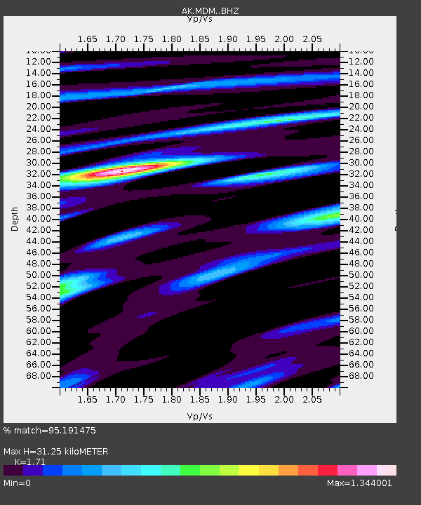
| Estimated Moho Depth: |
31.25 km |
| Estimated Crust Vp/Vs: |
1.71 |
| Assumed Crust Vp: |
6.566 km/s |
| Estimated Crust Vs: |
3.84 km/s |
| Estimated Crust Poisson's Ratio: |
0.24 |
|
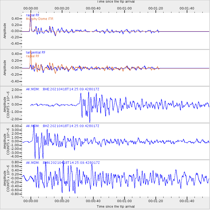
| Radial Match: |
95.191475 % |
| Radial Bump: |
343 |
| Transverse Match: |
77.47479 % |
| Transverse Bump: |
308 |
| SOD ConfigId: |
24334971 |
| Insert Time: |
2021-05-02 14:36:30.963 +0000 |
| GWidth: |
2.5 |
| Max Bumps: |
400 |
| Tol: |
0.001 |
|
Signal To Noise
| Channel | StoN | STA | LTA |
| AK:MDM: :BHZ:20210418T14:25:09.428017Z | 18.248259 | 1.8551357E-6 | 1.0166097E-7 |
| AK:MDM: :BHN:20210418T14:25:09.428017Z | 1.821691 | 2.0995672E-7 | 1.1525375E-7 |
| AK:MDM: :BHE:20210418T14:25:09.428017Z | 9.272151 | 6.959486E-7 | 7.505795E-8 |
| Arrivals |
| Ps | 3.5 SECOND |
| PpPs | 12 SECOND |
| PsPs/PpSs | 16 SECOND |


