You are here: Home > Network List > AK - Alaska Regional Network Stations List
> Station P17K Kvichak River, AK, USA > Earthquake Result Viewer
P17K Kvichak River, AK, USA - Earthquake Result Viewer
| Earthquake location: |
Taiwan |
| Earthquake latitude/longitude: |
23.9/121.5 |
| Earthquake time(UTC): |
2021/04/18 (108) 14:14:36 GMT |
| Earthquake Depth: |
10 km |
| Earthquake Magnitude: |
5.8 mww |
| Earthquake Catalog/Contributor: |
NEIC PDE/us |
|
| Network: |
AK Alaska Regional Network |
| Station: |
P17K Kvichak River, AK, USA |
| Lat/Lon: |
59.20 N/156.44 W |
| Elevation: |
91 m |
|
| Distance: |
65.8 deg |
| Az: |
33.98 deg |
| Baz: |
276.182 deg |
| Ray Param: |
0.058042627 |
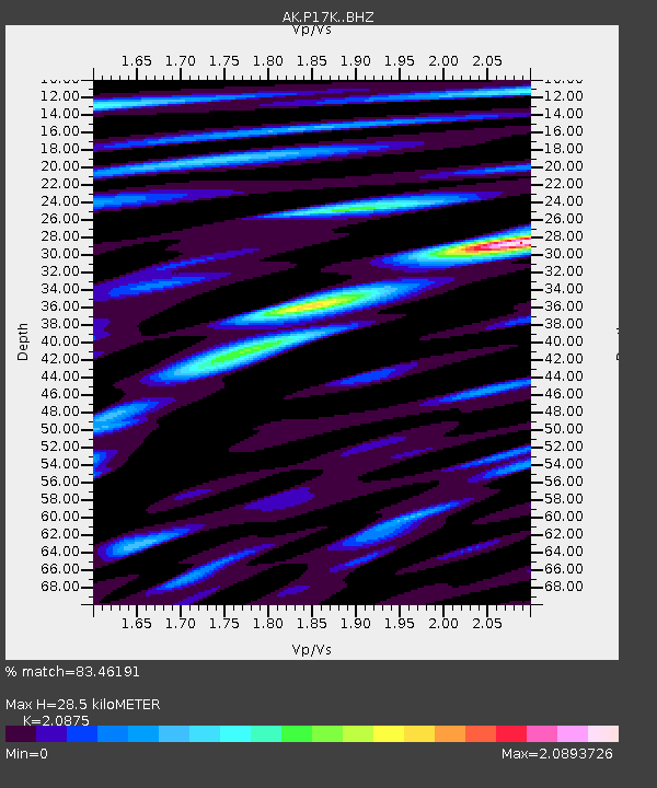
| Estimated Moho Depth: |
28.5 km |
| Estimated Crust Vp/Vs: |
2.09 |
| Assumed Crust Vp: |
6.276 km/s |
| Estimated Crust Vs: |
3.006 km/s |
| Estimated Crust Poisson's Ratio: |
0.35 |
|
| Radial Match: |
83.46191 % |
| Radial Bump: |
400 |
| Transverse Match: |
77.84251 % |
| Transverse Bump: |
400 |
| SOD ConfigId: |
24334971 |
| Insert Time: |
2021-05-02 14:36:45.488 +0000 |
| GWidth: |
2.5 |
| Max Bumps: |
400 |
| Tol: |
0.001 |
|

Signal To Noise
| Channel | StoN | STA | LTA |
| AK:P17K: :BHZ:20210418T14:24:50.619972Z | 27.139904 | 2.3961497E-6 | 8.828881E-8 |
| AK:P17K: :BHN:20210418T14:24:50.619972Z | 1.66904 | 3.8729874E-7 | 2.320488E-7 |
| AK:P17K: :BHE:20210418T14:24:50.619972Z | 4.7261114 | 9.821779E-7 | 2.0781944E-7 |
| Arrivals |
| Ps | 5.1 SECOND |
| PpPs | 14 SECOND |
| PsPs/PpSs | 19 SECOND |


