You are here: Home > Network List > US - United States National Seismic Network Stations List
> Station EGMT Eagleton, Montana, USA > Earthquake Result Viewer
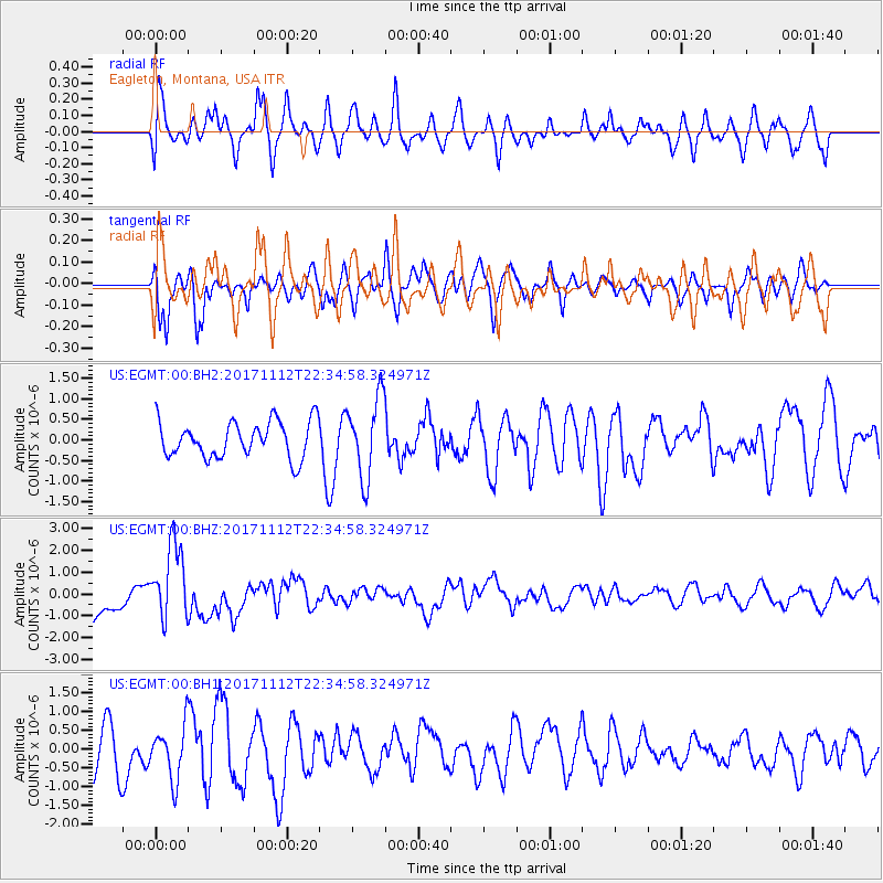
EGMT Eagleton, Montana, USA - Earthquake Result Viewer
*The percent match for this event was below the threshold and hence no stack was calculated.
| Earthquake location: |
Off East Coast Of Honshu, Japan |
| Earthquake latitude/longitude: |
38.1/144.9 |
| Earthquake time(UTC): |
2017/11/12 (316) 22:24:07 GMT |
| Earthquake Depth: |
9.5 km |
| Earthquake Magnitude: |
5.8 Mww |
| Earthquake Catalog/Contributor: |
NEIC PDE/us |
|
| Network: |
US United States National Seismic Network |
| Station: |
EGMT Eagleton, Montana, USA |
| Lat/Lon: |
48.02 N/109.75 W |
| Elevation: |
1055 m |
|
| Distance: |
71.7 deg |
| Az: |
42.998 deg |
| Baz: |
306.681 deg |
| Ray Param: |
$rayparam |
*The percent match for this event was below the threshold and hence was not used in the summary stack. |
|
| Radial Match: |
59.487232 % |
| Radial Bump: |
400 |
| Transverse Match: |
51.628506 % |
| Transverse Bump: |
394 |
| SOD ConfigId: |
2429771 |
| Insert Time: |
2017-11-26 22:29:52.673 +0000 |
| GWidth: |
2.5 |
| Max Bumps: |
400 |
| Tol: |
0.001 |
|
Signal To Noise
| Channel | StoN | STA | LTA |
| US:EGMT:00:BHZ:20171112T22:34:58.324971Z | 2.4633594 | 1.7918146E-6 | 7.273866E-7 |
| US:EGMT:00:BH1:20171112T22:34:58.324971Z | 1.2869968 | 7.023084E-7 | 5.4569546E-7 |
| US:EGMT:00:BH2:20171112T22:34:58.324971Z | 2.216828 | 9.712171E-7 | 4.3811116E-7 |
| Arrivals |
| Ps | |
| PpPs | |
| PsPs/PpSs | |


