You are here: Home > Network List > TA - USArray Transportable Network (new EarthScope stations) Stations List
> Station E28M Babbage River, YT, CAN > Earthquake Result Viewer
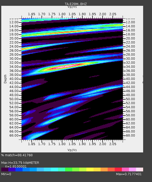
E28M Babbage River, YT, CAN - Earthquake Result Viewer
| Earthquake location: |
Taiwan |
| Earthquake latitude/longitude: |
23.9/121.5 |
| Earthquake time(UTC): |
2021/04/18 (108) 14:14:36 GMT |
| Earthquake Depth: |
10 km |
| Earthquake Magnitude: |
5.8 mww |
| Earthquake Catalog/Contributor: |
NEIC PDE/us |
|
| Network: |
TA USArray Transportable Network (new EarthScope stations) |
| Station: |
E28M Babbage River, YT, CAN |
| Lat/Lon: |
68.60 N/139.53 W |
| Elevation: |
474 m |
|
| Distance: |
71.2 deg |
| Az: |
22.514 deg |
| Baz: |
287.194 deg |
| Ray Param: |
0.05448114 |
| Estimated Moho Depth: |
33.75 km |
| Estimated Crust Vp/Vs: |
1.81 |
| Assumed Crust Vp: |
6.316 km/s |
| Estimated Crust Vs: |
3.49 km/s |
| Estimated Crust Poisson's Ratio: |
0.28 |
|
| Radial Match: |
88.41768 % |
| Radial Bump: |
400 |
| Transverse Match: |
79.43916 % |
| Transverse Bump: |
400 |
| SOD ConfigId: |
24334971 |
| Insert Time: |
2021-05-02 14:51:14.632 +0000 |
| GWidth: |
2.5 |
| Max Bumps: |
400 |
| Tol: |
0.001 |
|

Signal To Noise
| Channel | StoN | STA | LTA |
| TA:E28M: :BHZ:20210418T14:25:24.499977Z | 7.529483 | 8.121813E-7 | 1.0786681E-7 |
| TA:E28M: :BHN:20210418T14:25:24.499977Z | 2.332199 | 1.798557E-7 | 7.71185E-8 |
| TA:E28M: :BHE:20210418T14:25:24.499977Z | 3.7571073 | 2.7305524E-7 | 7.267698E-8 |
| Arrivals |
| Ps | 4.5 SECOND |
| PpPs | 15 SECOND |
| PsPs/PpSs | 19 SECOND |


