You are here: Home > Network List > TA - USArray Transportable Network (new EarthScope stations) Stations List
> Station E29M Blow River, YT, CAN > Earthquake Result Viewer
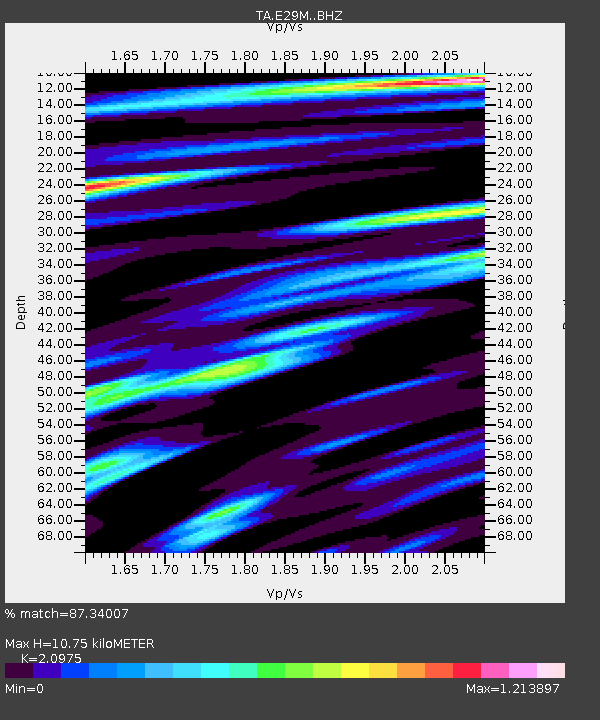
E29M Blow River, YT, CAN - Earthquake Result Viewer
| Earthquake location: |
Taiwan |
| Earthquake latitude/longitude: |
23.9/121.5 |
| Earthquake time(UTC): |
2021/04/18 (108) 14:14:36 GMT |
| Earthquake Depth: |
10 km |
| Earthquake Magnitude: |
5.8 mww |
| Earthquake Catalog/Contributor: |
NEIC PDE/us |
|
| Network: |
TA USArray Transportable Network (new EarthScope stations) |
| Station: |
E29M Blow River, YT, CAN |
| Lat/Lon: |
68.39 N/137.90 W |
| Elevation: |
324 m |
|
| Distance: |
71.8 deg |
| Az: |
22.534 deg |
| Baz: |
288.723 deg |
| Ray Param: |
0.054066487 |
| Estimated Moho Depth: |
10.75 km |
| Estimated Crust Vp/Vs: |
2.10 |
| Assumed Crust Vp: |
5.981 km/s |
| Estimated Crust Vs: |
2.852 km/s |
| Estimated Crust Poisson's Ratio: |
0.35 |
|
| Radial Match: |
87.34007 % |
| Radial Bump: |
400 |
| Transverse Match: |
76.33159 % |
| Transverse Bump: |
400 |
| SOD ConfigId: |
24334971 |
| Insert Time: |
2021-05-02 14:51:14.865 +0000 |
| GWidth: |
2.5 |
| Max Bumps: |
400 |
| Tol: |
0.001 |
|

Signal To Noise
| Channel | StoN | STA | LTA |
| TA:E29M: :BHZ:20210418T14:25:28.374977Z | 12.271239 | 7.233438E-7 | 5.8946274E-8 |
| TA:E29M: :BHN:20210418T14:25:28.374977Z | 2.2389135 | 1.2240947E-7 | 5.4673606E-8 |
| TA:E29M: :BHE:20210418T14:25:28.374977Z | 4.7192187 | 2.9798542E-7 | 6.3142956E-8 |
| Arrivals |
| Ps | 2.0 SECOND |
| PpPs | 5.4 SECOND |
| PsPs/PpSs | 7.4 SECOND |


