You are here: Home > Network List > TA - USArray Transportable Network (new EarthScope stations) Stations List
> Station G26K Porcupine River, AK, USA > Earthquake Result Viewer
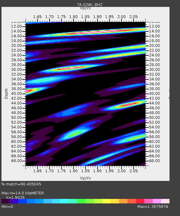
G26K Porcupine River, AK, USA - Earthquake Result Viewer
| Earthquake location: |
Taiwan |
| Earthquake latitude/longitude: |
23.9/121.5 |
| Earthquake time(UTC): |
2021/04/18 (108) 14:14:36 GMT |
| Earthquake Depth: |
10 km |
| Earthquake Magnitude: |
5.8 mww |
| Earthquake Catalog/Contributor: |
NEIC PDE/us |
|
| Network: |
TA USArray Transportable Network (new EarthScope stations) |
| Station: |
G26K Porcupine River, AK, USA |
| Lat/Lon: |
66.95 N/143.78 W |
| Elevation: |
180 m |
|
| Distance: |
70.1 deg |
| Az: |
24.67 deg |
| Baz: |
283.978 deg |
| Ray Param: |
0.055226393 |
| Estimated Moho Depth: |
14.0 km |
| Estimated Crust Vp/Vs: |
1.90 |
| Assumed Crust Vp: |
6.577 km/s |
| Estimated Crust Vs: |
3.457 km/s |
| Estimated Crust Poisson's Ratio: |
0.31 |
|
| Radial Match: |
90.405045 % |
| Radial Bump: |
400 |
| Transverse Match: |
87.432076 % |
| Transverse Bump: |
400 |
| SOD ConfigId: |
24334971 |
| Insert Time: |
2021-05-02 14:51:40.728 +0000 |
| GWidth: |
2.5 |
| Max Bumps: |
400 |
| Tol: |
0.001 |
|

Signal To Noise
| Channel | StoN | STA | LTA |
| TA:G26K: :BHZ:20210418T14:25:17.749977Z | 9.891792 | 9.915103E-7 | 1.0023566E-7 |
| TA:G26K: :BHN:20210418T14:25:17.749977Z | 3.0140111 | 3.786355E-7 | 1.2562512E-7 |
| TA:G26K: :BHE:20210418T14:25:17.749977Z | 4.3609886 | 5.368285E-7 | 1.230979E-7 |
| Arrivals |
| Ps | 2.0 SECOND |
| PpPs | 6.0 SECOND |
| PsPs/PpSs | 8.0 SECOND |


