You are here: Home > Network List > TA - USArray Transportable Network (new EarthScope stations) Stations List
> Station I17K Unalakleet, AK, USA > Earthquake Result Viewer
I17K Unalakleet, AK, USA - Earthquake Result Viewer
| Earthquake location: |
Taiwan |
| Earthquake latitude/longitude: |
23.9/121.5 |
| Earthquake time(UTC): |
2021/04/18 (108) 14:14:36 GMT |
| Earthquake Depth: |
10 km |
| Earthquake Magnitude: |
5.8 mww |
| Earthquake Catalog/Contributor: |
NEIC PDE/us |
|
| Network: |
TA USArray Transportable Network (new EarthScope stations) |
| Station: |
I17K Unalakleet, AK, USA |
| Lat/Lon: |
63.89 N/160.70 W |
| Elevation: |
105 m |
|
| Distance: |
63.5 deg |
| Az: |
28.908 deg |
| Baz: |
270.267 deg |
| Ray Param: |
0.059561122 |
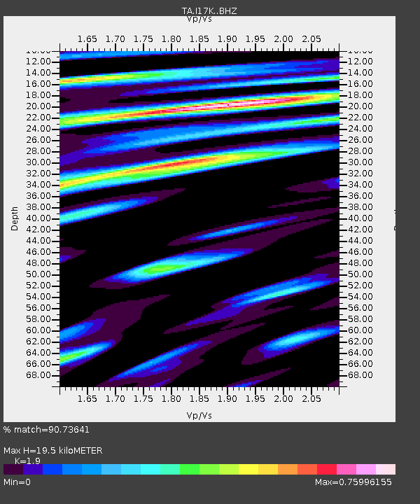
| Estimated Moho Depth: |
19.5 km |
| Estimated Crust Vp/Vs: |
1.90 |
| Assumed Crust Vp: |
6.276 km/s |
| Estimated Crust Vs: |
3.303 km/s |
| Estimated Crust Poisson's Ratio: |
0.31 |
|
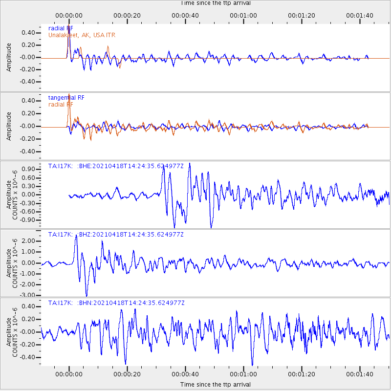
| Radial Match: |
90.73641 % |
| Radial Bump: |
400 |
| Transverse Match: |
76.142784 % |
| Transverse Bump: |
400 |
| SOD ConfigId: |
24334971 |
| Insert Time: |
2021-05-02 14:51:54.864 +0000 |
| GWidth: |
2.5 |
| Max Bumps: |
400 |
| Tol: |
0.001 |
|
Signal To Noise
| Channel | StoN | STA | LTA |
| TA:I17K: :BHZ:20210418T14:24:35.624977Z | 7.4677787 | 1.0815321E-6 | 1.4482647E-7 |
| TA:I17K: :BHN:20210418T14:24:35.624977Z | 0.9275376 | 9.466747E-8 | 1.0206322E-7 |
| TA:I17K: :BHE:20210418T14:24:35.624977Z | 5.93468 | 4.6866995E-7 | 7.897139E-8 |
| Arrivals |
| Ps | 2.9 SECOND |
| PpPs | 8.7 SECOND |
| PsPs/PpSs | 12 SECOND |


