You are here: Home > Network List > TA - USArray Transportable Network (new EarthScope stations) Stations List
> Station I30M Mount Dempster, Yukon, CAN > Earthquake Result Viewer
I30M Mount Dempster, Yukon, CAN - Earthquake Result Viewer
| Earthquake location: |
Taiwan |
| Earthquake latitude/longitude: |
23.9/121.5 |
| Earthquake time(UTC): |
2021/04/18 (108) 14:14:36 GMT |
| Earthquake Depth: |
10 km |
| Earthquake Magnitude: |
5.8 mww |
| Earthquake Catalog/Contributor: |
NEIC PDE/us |
|
| Network: |
TA USArray Transportable Network (new EarthScope stations) |
| Station: |
I30M Mount Dempster, Yukon, CAN |
| Lat/Lon: |
65.22 N/136.38 W |
| Elevation: |
1399 m |
|
| Distance: |
73.5 deg |
| Az: |
25.454 deg |
| Baz: |
290.99 deg |
| Ray Param: |
0.05296988 |
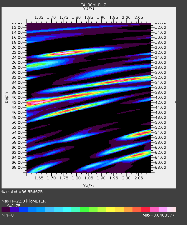
| Estimated Moho Depth: |
22.0 km |
| Estimated Crust Vp/Vs: |
1.75 |
| Assumed Crust Vp: |
6.566 km/s |
| Estimated Crust Vs: |
3.752 km/s |
| Estimated Crust Poisson's Ratio: |
0.26 |
|
| Radial Match: |
86.556625 % |
| Radial Bump: |
400 |
| Transverse Match: |
81.41276 % |
| Transverse Bump: |
400 |
| SOD ConfigId: |
24334971 |
| Insert Time: |
2021-05-02 14:52:00.598 +0000 |
| GWidth: |
2.5 |
| Max Bumps: |
400 |
| Tol: |
0.001 |
|
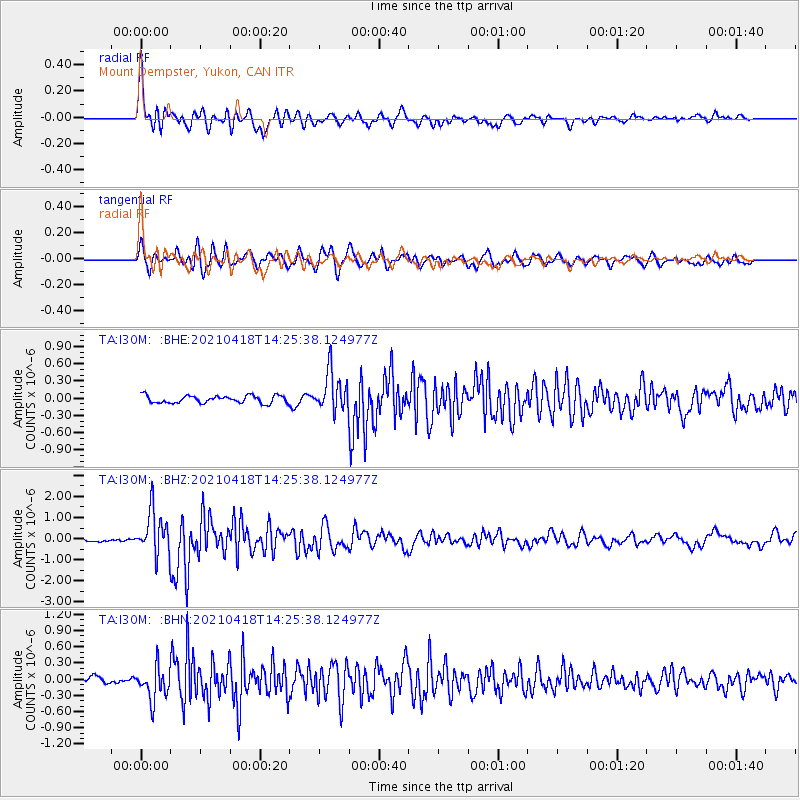
Signal To Noise
| Channel | StoN | STA | LTA |
| TA:I30M: :BHZ:20210418T14:25:38.124977Z | 12.709835 | 1.0229104E-6 | 8.04818E-8 |
| TA:I30M: :BHN:20210418T14:25:38.124977Z | 4.4372435 | 2.9772957E-7 | 6.7097865E-8 |
| TA:I30M: :BHE:20210418T14:25:38.124977Z | 5.2882104 | 3.4177813E-7 | 6.463021E-8 |
| Arrivals |
| Ps | 2.6 SECOND |
| PpPs | 8.9 SECOND |
| PsPs/PpSs | 11 SECOND |


