You are here: Home > Network List > TA - USArray Transportable Network (new EarthScope stations) Stations List
> Station K17K Iditarod, AK, USA > Earthquake Result Viewer
K17K Iditarod, AK, USA - Earthquake Result Viewer
| Earthquake location: |
Taiwan |
| Earthquake latitude/longitude: |
23.9/121.5 |
| Earthquake time(UTC): |
2021/04/18 (108) 14:14:36 GMT |
| Earthquake Depth: |
10 km |
| Earthquake Magnitude: |
5.8 mww |
| Earthquake Catalog/Contributor: |
NEIC PDE/us |
|
| Network: |
TA USArray Transportable Network (new EarthScope stations) |
| Station: |
K17K Iditarod, AK, USA |
| Lat/Lon: |
62.72 N/158.30 W |
| Elevation: |
339 m |
|
| Distance: |
64.6 deg |
| Az: |
30.18 deg |
| Baz: |
272.96 deg |
| Ray Param: |
0.058832746 |
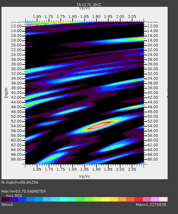
| Estimated Moho Depth: |
53.75 km |
| Estimated Crust Vp/Vs: |
1.90 |
| Assumed Crust Vp: |
6.276 km/s |
| Estimated Crust Vs: |
3.294 km/s |
| Estimated Crust Poisson's Ratio: |
0.31 |
|
| Radial Match: |
88.84256 % |
| Radial Bump: |
400 |
| Transverse Match: |
85.7576 % |
| Transverse Bump: |
400 |
| SOD ConfigId: |
24334971 |
| Insert Time: |
2021-05-02 14:52:09.315 +0000 |
| GWidth: |
2.5 |
| Max Bumps: |
400 |
| Tol: |
0.001 |
|

Signal To Noise
| Channel | StoN | STA | LTA |
| TA:K17K: :BHZ:20210418T14:24:42.925026Z | 11.111807 | 1.1174692E-6 | 1.0056593E-7 |
| TA:K17K: :BHN:20210418T14:24:42.925026Z | 0.8400243 | 1.13689964E-7 | 1.3534128E-7 |
| TA:K17K: :BHE:20210418T14:24:42.925026Z | 5.549085 | 4.4276769E-7 | 7.9791114E-8 |
| Arrivals |
| Ps | 8.0 SECOND |
| PpPs | 24 SECOND |
| PsPs/PpSs | 32 SECOND |


