You are here: Home > Network List > TA - USArray Transportable Network (new EarthScope stations) Stations List
> Station N17K Nushagak Hills, AK, USA > Earthquake Result Viewer
N17K Nushagak Hills, AK, USA - Earthquake Result Viewer
| Earthquake location: |
Taiwan |
| Earthquake latitude/longitude: |
23.9/121.5 |
| Earthquake time(UTC): |
2021/04/18 (108) 14:14:36 GMT |
| Earthquake Depth: |
10 km |
| Earthquake Magnitude: |
5.8 mww |
| Earthquake Catalog/Contributor: |
NEIC PDE/us |
|
| Network: |
TA USArray Transportable Network (new EarthScope stations) |
| Station: |
N17K Nushagak Hills, AK, USA |
| Lat/Lon: |
60.53 N/157.19 W |
| Elevation: |
350 m |
|
| Distance: |
65.3 deg |
| Az: |
32.559 deg |
| Baz: |
274.948 deg |
| Ray Param: |
0.058387745 |
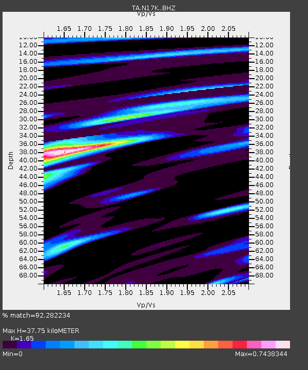
| Estimated Moho Depth: |
37.75 km |
| Estimated Crust Vp/Vs: |
1.65 |
| Assumed Crust Vp: |
6.155 km/s |
| Estimated Crust Vs: |
3.73 km/s |
| Estimated Crust Poisson's Ratio: |
0.21 |
|
| Radial Match: |
92.282234 % |
| Radial Bump: |
284 |
| Transverse Match: |
81.68379 % |
| Transverse Bump: |
400 |
| SOD ConfigId: |
24334971 |
| Insert Time: |
2021-05-02 14:52:28.630 +0000 |
| GWidth: |
2.5 |
| Max Bumps: |
400 |
| Tol: |
0.001 |
|

Signal To Noise
| Channel | StoN | STA | LTA |
| TA:N17K: :BHZ:20210418T14:24:47.374977Z | 11.332502 | 1.1261773E-6 | 9.937587E-8 |
| TA:N17K: :BHN:20210418T14:24:47.374977Z | 1.854893 | 1.4221372E-7 | 7.666951E-8 |
| TA:N17K: :BHE:20210418T14:24:47.374977Z | 8.650635 | 5.5301985E-7 | 6.392823E-8 |
| Arrivals |
| Ps | 4.2 SECOND |
| PpPs | 16 SECOND |
| PsPs/PpSs | 20 SECOND |


