You are here: Home > Network List > WY - Yellowstone Wyoming Seismic Network Stations List
> Station YHH Holmes Hill, YNP, WY, USA > Earthquake Result Viewer
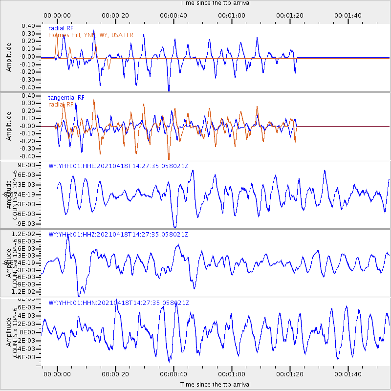
YHH Holmes Hill, YNP, WY, USA - Earthquake Result Viewer
*The percent match for this event was below the threshold and hence no stack was calculated.
| Earthquake location: |
Taiwan |
| Earthquake latitude/longitude: |
23.9/121.5 |
| Earthquake time(UTC): |
2021/04/18 (108) 14:14:36 GMT |
| Earthquake Depth: |
10 km |
| Earthquake Magnitude: |
5.8 mww |
| Earthquake Catalog/Contributor: |
NEIC PDE/us |
|
| Network: |
WY Yellowstone Wyoming Seismic Network |
| Station: |
YHH Holmes Hill, YNP, WY, USA |
| Lat/Lon: |
44.79 N/110.85 W |
| Elevation: |
2717 m |
|
| Distance: |
96.6 deg |
| Az: |
34.601 deg |
| Baz: |
313.11 deg |
| Ray Param: |
$rayparam |
*The percent match for this event was below the threshold and hence was not used in the summary stack. |
|
| Radial Match: |
65.99082 % |
| Radial Bump: |
383 |
| Transverse Match: |
51.381935 % |
| Transverse Bump: |
400 |
| SOD ConfigId: |
24334971 |
| Insert Time: |
2021-05-02 14:56:09.154 +0000 |
| GWidth: |
2.5 |
| Max Bumps: |
400 |
| Tol: |
0.001 |
|
Signal To Noise
| Channel | StoN | STA | LTA |
| WY:YHH:01:HHZ:20210418T14:27:35.058021Z | 2.3844764 | 5.128779E-9 | 2.1509037E-9 |
| WY:YHH:01:HHN:20210418T14:27:35.058021Z | 0.52347624 | 1.4461063E-9 | 2.762506E-9 |
| WY:YHH:01:HHE:20210418T14:27:35.058021Z | 0.42710134 | 1.2736452E-9 | 2.9820677E-9 |
| Arrivals |
| Ps | |
| PpPs | |
| PsPs/PpSs | |


