You are here: Home > Network List > US - United States National Seismic Network Stations List
> Station WRAK Wrangell Island, Southeastern Alaska, Alaska, USA > Earthquake Result Viewer
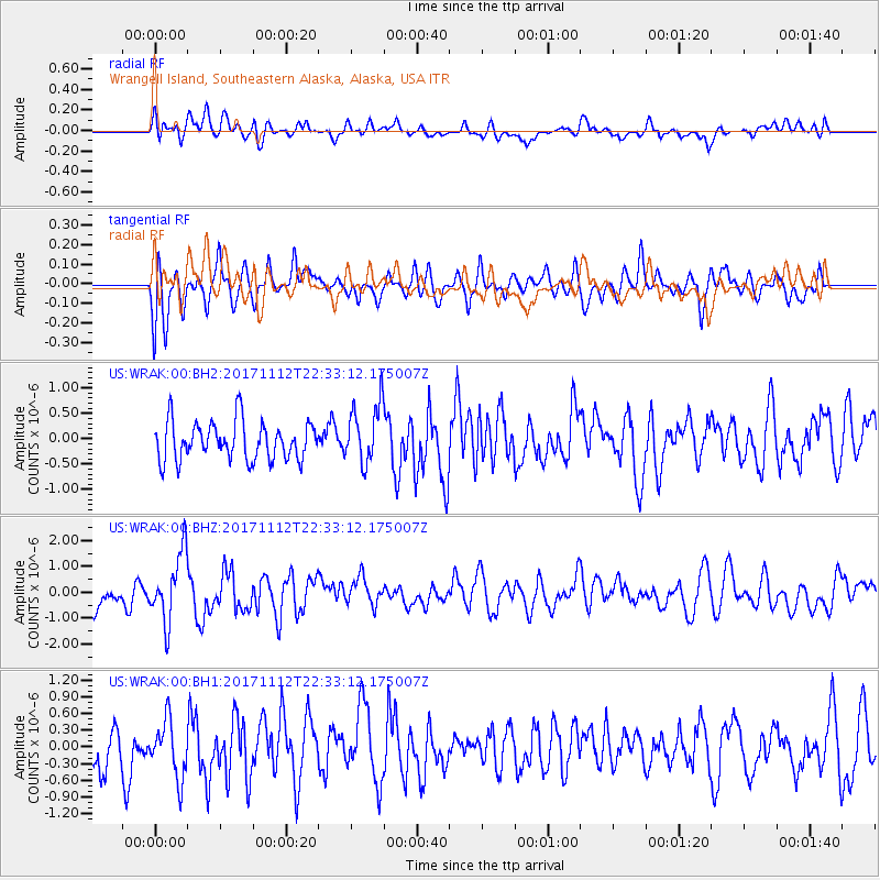
WRAK Wrangell Island, Southeastern Alaska, Alaska, USA - Earthquake Result Viewer
*The percent match for this event was below the threshold and hence no stack was calculated.
| Earthquake location: |
Off East Coast Of Honshu, Japan |
| Earthquake latitude/longitude: |
38.1/144.9 |
| Earthquake time(UTC): |
2017/11/12 (316) 22:24:07 GMT |
| Earthquake Depth: |
9.5 km |
| Earthquake Magnitude: |
5.8 Mww |
| Earthquake Catalog/Contributor: |
NEIC PDE/us |
|
| Network: |
US United States National Seismic Network |
| Station: |
WRAK Wrangell Island, Southeastern Alaska, Alaska, USA |
| Lat/Lon: |
56.42 N/132.35 W |
| Elevation: |
81 m |
|
| Distance: |
55.6 deg |
| Az: |
41.949 deg |
| Baz: |
288.264 deg |
| Ray Param: |
$rayparam |
*The percent match for this event was below the threshold and hence was not used in the summary stack. |
|
| Radial Match: |
51.956917 % |
| Radial Bump: |
400 |
| Transverse Match: |
56.554733 % |
| Transverse Bump: |
400 |
| SOD ConfigId: |
2429771 |
| Insert Time: |
2017-11-26 22:30:34.903 +0000 |
| GWidth: |
2.5 |
| Max Bumps: |
400 |
| Tol: |
0.001 |
|
Signal To Noise
| Channel | StoN | STA | LTA |
| US:WRAK:00:BHZ:20171112T22:33:12.175007Z | 3.0432463 | 1.3088654E-6 | 4.300886E-7 |
| US:WRAK:00:BH1:20171112T22:33:12.175007Z | 1.0586383 | 5.154748E-7 | 4.869225E-7 |
| US:WRAK:00:BH2:20171112T22:33:12.175007Z | 1.5868104 | 5.967602E-7 | 3.760753E-7 |
| Arrivals |
| Ps | |
| PpPs | |
| PsPs/PpSs | |


