KDJ XW.KDJ - Earthquake Result Viewer
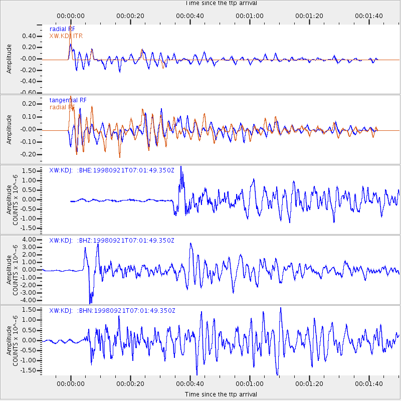
Earthquake location: Minahassa Peninsula, Sulawesi
Earthquake latitude/longitude: 0.3/122.5
Earthquake time(UTC): 1998/09/21 (264) 06:52:41 GMT
Earthquake Depth: 147 km
Earthquake Magnitude: 6.1 MB, 6.0 UNKNOWN, 5.9 MW
Earthquake Catalog/Contributor: WHDF/NEIC
Network: XW Tien Shan Continental Dynamics
Station: KDJ XW.KDJ
Lat/Lon: 42.13 N/77.19 E
Elevation: 1783 m
Distance: 58.2 deg
Az: 321.563 deg
Baz: 123.308 deg
Ray Param: 0.0625172
Estimated Moho Depth: 60.25 km
Estimated Crust Vp/Vs: 1.72
Assumed Crust Vp: 6.306 km/s
Estimated Crust Vs: 3.661 km/s
Estimated Crust Poisson's Ratio: 0.25
Radial Match: 90.738464 %
Radial Bump: 400
Transverse Match: 92.024414 %
Transverse Bump: 400
SOD ConfigId: 4480
Insert Time: 2010-02-26 15:31:11.719 +0000
GWidth: 2.5
Max Bumps: 400
Tol: 0.001

Signal To Noise

ChannelStoNSTALTA
XW:KDJ: :BHZ:19980921T07:01:49.350Z8.944256.9666385E-77.788958E-8
XW:KDJ: :BHN:19980921T07:01:49.350Z1.32389446.844264E-85.169796E-8
XW:KDJ: :BHE:19980921T07:01:49.350Z4.2572941.655984E-73.8897568E-8
Arrivals
Ps7.2 SECOND
PpPs25 SECOND
PsPs/PpSs32 SECOND