You are here: Home > Network List > IW - Intermountain West Stations List
> Station RRI2 Red Ridge, Idaho, USA > Earthquake Result Viewer
RRI2 Red Ridge, Idaho, USA - Earthquake Result Viewer
| Earthquake location: |
East Of Kuril Islands |
| Earthquake latitude/longitude: |
46.0/154.2 |
| Earthquake time(UTC): |
2007/10/25 (298) 13:50:02 GMT |
| Earthquake Depth: |
10 km |
| Earthquake Magnitude: |
6.0 MB, 5.7 MS, 6.1 MW, 5.9 MW |
| Earthquake Catalog/Contributor: |
WHDF/NEIC |
|
| Network: |
IW Intermountain West |
| Station: |
RRI2 Red Ridge, Idaho, USA |
| Lat/Lon: |
43.35 N/111.32 W |
| Elevation: |
2558 m |
|
| Distance: |
63.2 deg |
| Az: |
54.577 deg |
| Baz: |
308.874 deg |
| Ray Param: |
0.059737608 |
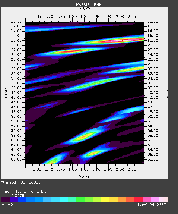
| Estimated Moho Depth: |
17.75 km |
| Estimated Crust Vp/Vs: |
2.01 |
| Assumed Crust Vp: |
6.207 km/s |
| Estimated Crust Vs: |
3.092 km/s |
| Estimated Crust Poisson's Ratio: |
0.33 |
|
| Radial Match: |
85.416336 % |
| Radial Bump: |
400 |
| Transverse Match: |
68.61528 % |
| Transverse Bump: |
400 |
| SOD ConfigId: |
2564 |
| Insert Time: |
2010-03-09 07:30:29.166 +0000 |
| GWidth: |
2.5 |
| Max Bumps: |
400 |
| Tol: |
0.001 |
|

Signal To Noise
| Channel | StoN | STA | LTA |
| IW:RRI2: :BHN:20071025T13:59:59.664006Z | 3.1782618 | 2.958478E-7 | 9.308478E-8 |
| IW:RRI2: :BHE:20071025T13:59:59.664006Z | 1.4820185 | 1.9205252E-7 | 1.2958849E-7 |
| IW:RRI2: :BHZ:20071025T13:59:59.664006Z | 8.433185 | 6.9687104E-7 | 8.2634386E-8 |
| Arrivals |
| Ps | 3.0 SECOND |
| PpPs | 8.3 SECOND |
| PsPs/PpSs | 11 SECOND |


