You are here: Home > Network List > AU - Australian Seismological Centre Stations List
> Station WB2 Warramunga Array, Australia > Earthquake Result Viewer
WB2 Warramunga Array, Australia - Earthquake Result Viewer
| Earthquake location: |
Off W Coast Of Northern Sumatra |
| Earthquake latitude/longitude: |
0.2/96.5 |
| Earthquake time(UTC): |
2021/04/19 (109) 23:58:22 GMT |
| Earthquake Depth: |
10 km |
| Earthquake Magnitude: |
6.0 mww |
| Earthquake Catalog/Contributor: |
NEIC PDE/us |
|
| Network: |
AU Australian Seismological Centre |
| Station: |
WB2 Warramunga Array, Australia |
| Lat/Lon: |
19.94 S/134.35 E |
| Elevation: |
388 m |
|
| Distance: |
42.1 deg |
| Az: |
120.62 deg |
| Baz: |
293.831 deg |
| Ray Param: |
0.073382534 |
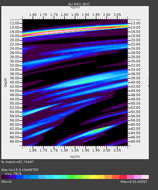
| Estimated Moho Depth: |
15.5 km |
| Estimated Crust Vp/Vs: |
1.79 |
| Assumed Crust Vp: |
6.642 km/s |
| Estimated Crust Vs: |
3.705 km/s |
| Estimated Crust Poisson's Ratio: |
0.27 |
|
| Radial Match: |
92.74467 % |
| Radial Bump: |
400 |
| Transverse Match: |
78.28408 % |
| Transverse Bump: |
400 |
| SOD ConfigId: |
24334971 |
| Insert Time: |
2021-05-04 00:03:01.077 +0000 |
| GWidth: |
2.5 |
| Max Bumps: |
400 |
| Tol: |
0.001 |
|

Signal To Noise
| Channel | StoN | STA | LTA |
| AU:WB2: :BHZ:20210420T00:05:43.500003Z | 19.93045 | 2.3117825E-6 | 1.1599249E-7 |
| AU:WB2: :BHN:20210420T00:05:43.500003Z | 5.351739 | 7.309137E-7 | 1.3657498E-7 |
| AU:WB2: :BHE:20210420T00:05:43.500003Z | 9.382882 | 1.3765545E-6 | 1.4670913E-7 |
| Arrivals |
| Ps | 2.0 SECOND |
| PpPs | 6.1 SECOND |
| PsPs/PpSs | 8.1 SECOND |


