You are here: Home > Network List > IW - Intermountain West Stations List
> Station RRI2 Red Ridge, Idaho, USA > Earthquake Result Viewer
RRI2 Red Ridge, Idaho, USA - Earthquake Result Viewer
| Earthquake location: |
Near Coast Of Venezuela |
| Earthquake latitude/longitude: |
10.7/-67.9 |
| Earthquake time(UTC): |
2009/09/12 (255) 20:06:24 GMT |
| Earthquake Depth: |
10 km |
| Earthquake Magnitude: |
6.3 MB, 6.4 MS, 6.3 MW, 6.3 MW |
| Earthquake Catalog/Contributor: |
WHDF/NEIC |
|
| Network: |
IW Intermountain West |
| Station: |
RRI2 Red Ridge, Idaho, USA |
| Lat/Lon: |
43.35 N/111.32 W |
| Elevation: |
2558 m |
|
| Distance: |
49.7 deg |
| Az: |
318.892 deg |
| Baz: |
117.651 deg |
| Ray Param: |
0.068551585 |
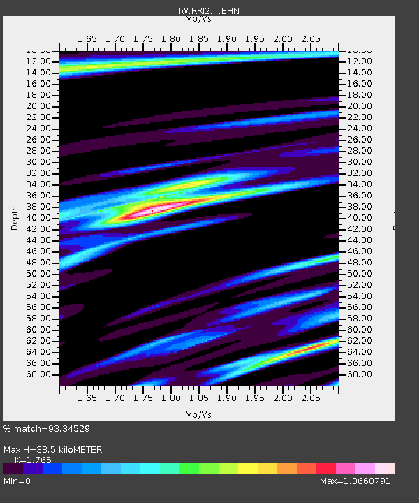
| Estimated Moho Depth: |
38.5 km |
| Estimated Crust Vp/Vs: |
1.76 |
| Assumed Crust Vp: |
6.207 km/s |
| Estimated Crust Vs: |
3.517 km/s |
| Estimated Crust Poisson's Ratio: |
0.26 |
|
| Radial Match: |
93.34529 % |
| Radial Bump: |
372 |
| Transverse Match: |
79.00896 % |
| Transverse Bump: |
400 |
| SOD ConfigId: |
2622 |
| Insert Time: |
2010-03-09 07:30:40.251 +0000 |
| GWidth: |
2.5 |
| Max Bumps: |
400 |
| Tol: |
0.001 |
|

Signal To Noise
| Channel | StoN | STA | LTA |
| IW:RRI2: :BHN:20090912T20:14:45.568987Z | 8.67337 | 7.694371E-7 | 8.871259E-8 |
| IW:RRI2: :BHE:20090912T20:14:45.568987Z | 2.2014205 | 4.3736435E-7 | 1.986737E-7 |
| IW:RRI2: :BHZ:20090912T20:14:45.568987Z | 4.276792 | 4.6840643E-7 | 1.09522844E-7 |
| Arrivals |
| Ps | 5.0 SECOND |
| PpPs | 16 SECOND |
| PsPs/PpSs | 21 SECOND |


