You are here: Home > Network List > IW - Intermountain West Stations List
> Station RRI2 Red Ridge, Idaho, USA > Earthquake Result Viewer
RRI2 Red Ridge, Idaho, USA - Earthquake Result Viewer
| Earthquake location: |
North Of Svalbard |
| Earthquake latitude/longitude: |
80.3/-1.9 |
| Earthquake time(UTC): |
2009/03/06 (065) 10:50:29 GMT |
| Earthquake Depth: |
9.0 km |
| Earthquake Magnitude: |
6.6 MB, 6.5 MS, 6.5 MW, 6.4 MW |
| Earthquake Catalog/Contributor: |
WHDF/NEIC |
|
| Network: |
IW Intermountain West |
| Station: |
RRI2 Red Ridge, Idaho, USA |
| Lat/Lon: |
43.35 N/111.32 W |
| Elevation: |
2558 m |
|
| Distance: |
50.7 deg |
| Az: |
297.322 deg |
| Baz: |
11.89 deg |
| Ray Param: |
0.06786314 |
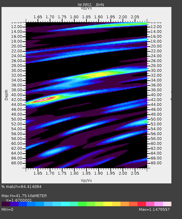
| Estimated Moho Depth: |
41.75 km |
| Estimated Crust Vp/Vs: |
1.67 |
| Assumed Crust Vp: |
6.207 km/s |
| Estimated Crust Vs: |
3.717 km/s |
| Estimated Crust Poisson's Ratio: |
0.22 |
|
| Radial Match: |
94.414894 % |
| Radial Bump: |
400 |
| Transverse Match: |
88.62858 % |
| Transverse Bump: |
400 |
| SOD ConfigId: |
2658 |
| Insert Time: |
2010-03-09 07:30:51.096 +0000 |
| GWidth: |
2.5 |
| Max Bumps: |
400 |
| Tol: |
0.001 |
|

Signal To Noise
| Channel | StoN | STA | LTA |
| IW:RRI2: :BHN:20090306T10:58:58.463986Z | 25.010756 | 4.7371873E-6 | 1.89406E-7 |
| IW:RRI2: :BHE:20090306T10:58:58.463986Z | 10.860765 | 2.8234845E-6 | 2.5997105E-7 |
| IW:RRI2: :BHZ:20090306T10:58:58.463986Z | 3.5743647 | 1.2255715E-6 | 3.4287817E-7 |
| Arrivals |
| Ps | 4.8 SECOND |
| PpPs | 17 SECOND |
| PsPs/PpSs | 22 SECOND |


