You are here: Home > Network List > GO - National Seismic Network of Georgia Stations List
> Station TBLG Delisi, Georgia > Earthquake Result Viewer
TBLG Delisi, Georgia - Earthquake Result Viewer

| Earthquake location: |
Off W Coast Of Northern Sumatra |
| Earthquake latitude/longitude: |
0.2/96.5 |
| Earthquake time(UTC): |
2021/04/19 (109) 23:58:22 GMT |
| Earthquake Depth: |
10 km |
| Earthquake Magnitude: |
6.0 mww |
| Earthquake Catalog/Contributor: |
NEIC PDE/us |
|
| Network: |
GO National Seismic Network of Georgia |
| Station: |
TBLG Delisi, Georgia |
| Lat/Lon: |
41.73 N/44.74 E |
| Elevation: |
510 m |
|
| Distance: |
62.3 deg |
| Az: |
318.364 deg |
| Baz: |
117.423 deg |
| Ray Param: |
0.060323965 |
| Estimated Moho Depth: |
60.75 km |
| Estimated Crust Vp/Vs: |
1.62 |
| Assumed Crust Vp: |
6.291 km/s |
| Estimated Crust Vs: |
3.871 km/s |
| Estimated Crust Poisson's Ratio: |
0.20 |
|
| Radial Match: |
87.00698 % |
| Radial Bump: |
400 |
| Transverse Match: |
77.21441 % |
| Transverse Bump: |
400 |
| SOD ConfigId: |
24334971 |
| Insert Time: |
2021-05-04 00:05:28.174 +0000 |
| GWidth: |
2.5 |
| Max Bumps: |
400 |
| Tol: |
0.001 |
|
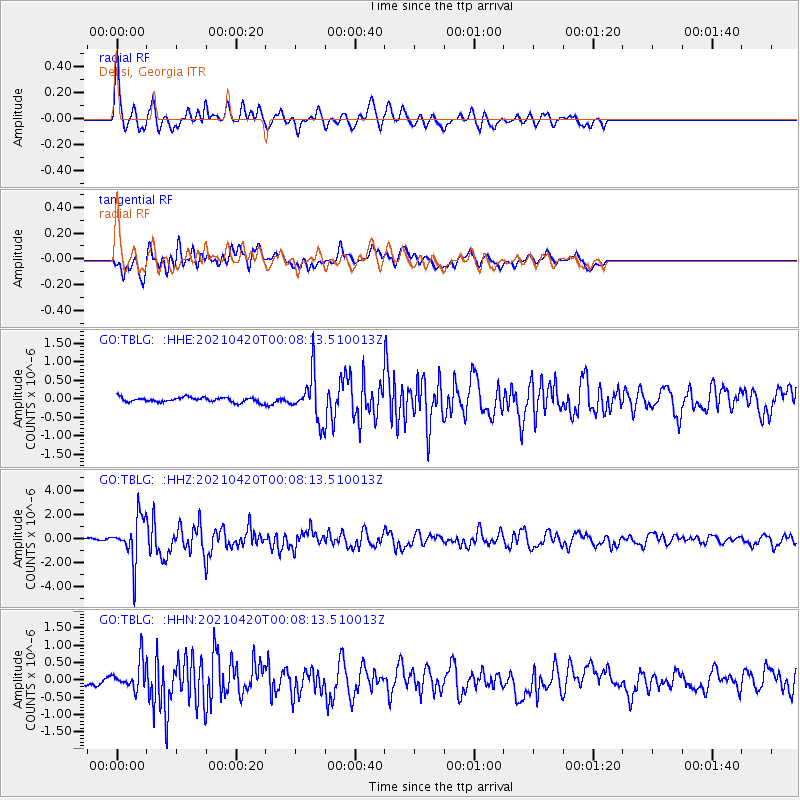
Signal To Noise
| Channel | StoN | STA | LTA |
| GO:TBLG: :HHZ:20210420T00:08:13.510013Z | 21.669367 | 1.8429492E-6 | 8.504859E-8 |
| GO:TBLG: :HHN:20210420T00:08:13.510013Z | 2.5070508 | 3.94473E-7 | 1.5734543E-7 |
| GO:TBLG: :HHE:20210420T00:08:13.510013Z | 9.326549 | 6.011062E-7 | 6.4451086E-8 |
| Arrivals |
| Ps | 6.3 SECOND |
| PpPs | 24 SECOND |
| PsPs/PpSs | 31 SECOND |


