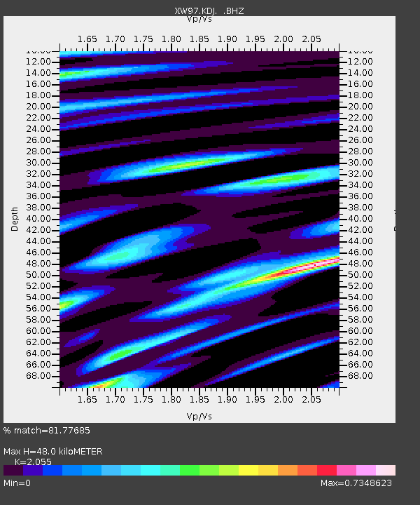
KDJ XW.KDJ - Earthquake Result Viewer
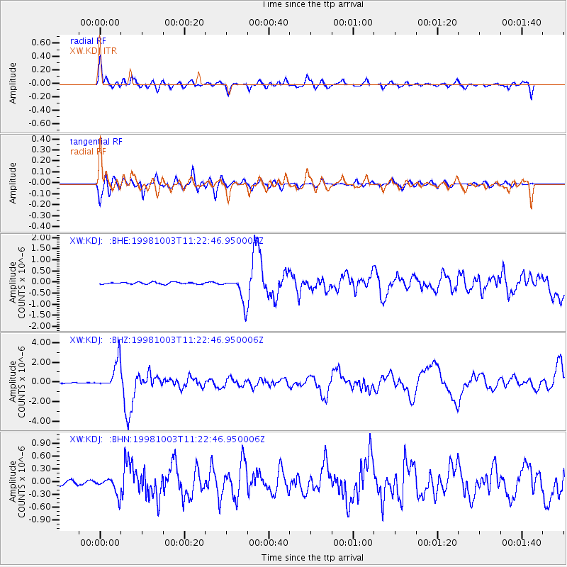
Earthquake location: Northwest Of Ryukyu Islands
Earthquake latitude/longitude: 28.5/127.6
Earthquake time(UTC): 1998/10/03 (276) 11:15:42 GMT
Earthquake Depth: 227 km
Earthquake Magnitude: 5.6 MB, 6.1 UNKNOWN, 6.1 MW
Earthquake Catalog/Contributor: WHDF/NEIC
Network: XW Tien Shan Continental Dynamics
Station: KDJ XW.KDJ
Lat/Lon: 42.13 N/77.19 E
Elevation: 1783 m
Distance: 42.7 deg
Az: 302.357 deg
Baz: 91.822 deg
Ray Param: 0.07207552
Estimated Moho Depth: 48.0 km
Estimated Crust Vp/Vs: 2.06
Assumed Crust Vp: 6.306 km/s
Estimated Crust Vs: 3.069 km/s
Estimated Crust Poisson's Ratio: 0.34
Radial Match: 81.77685 %
Radial Bump: 400
Transverse Match: 77.00126 %
Transverse Bump: 400
SOD ConfigId: 4480
Insert Time: 2010-02-26 15:31:15.130 +0000
GWidth: 2.5
Max Bumps: 400
Tol: 0.001

Signal To Noise

ChannelStoNSTALTA
XW:KDJ: :BHZ:19981003T11:22:46.950006Z29.9226991.4911757E-64.9834263E-8
XW:KDJ: :BHN:19981003T11:22:46.950006Z4.08294342.0662209E-75.060616E-8
XW:KDJ: :BHE:19981003T11:22:46.950006Z14.6478886.1429546E-74.1937476E-8
Arrivals
Ps8.5 SECOND
PpPs22 SECOND
PsPs/PpSs31 SECOND