You are here: Home > Network List > IW - Intermountain West Stations List
> Station RRI2 Red Ridge, Idaho, USA > Earthquake Result Viewer
RRI2 Red Ridge, Idaho, USA - Earthquake Result Viewer
| Earthquake location: |
Tonga Islands Region |
| Earthquake latitude/longitude: |
-23.0/-174.7 |
| Earthquake time(UTC): |
2009/03/19 (078) 18:17:40 GMT |
| Earthquake Depth: |
34 km |
| Earthquake Magnitude: |
7.0 MB, 7.6 MS, 7.6 MW, 7.6 MW |
| Earthquake Catalog/Contributor: |
WHDF/NEIC |
|
| Network: |
IW Intermountain West |
| Station: |
RRI2 Red Ridge, Idaho, USA |
| Lat/Lon: |
43.35 N/111.32 W |
| Elevation: |
2558 m |
|
| Distance: |
88.0 deg |
| Az: |
40.719 deg |
| Baz: |
235.458 deg |
| Ray Param: |
0.042883907 |
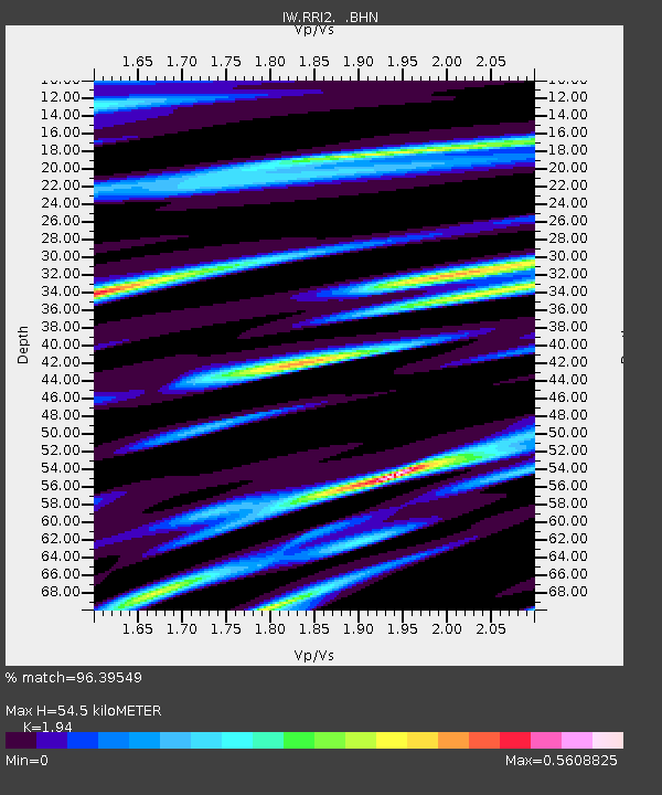
| Estimated Moho Depth: |
54.5 km |
| Estimated Crust Vp/Vs: |
1.94 |
| Assumed Crust Vp: |
6.207 km/s |
| Estimated Crust Vs: |
3.199 km/s |
| Estimated Crust Poisson's Ratio: |
0.32 |
|
| Radial Match: |
96.39549 % |
| Radial Bump: |
400 |
| Transverse Match: |
85.100525 % |
| Transverse Bump: |
400 |
| SOD ConfigId: |
2658 |
| Insert Time: |
2010-03-09 07:30:57.910 +0000 |
| GWidth: |
2.5 |
| Max Bumps: |
400 |
| Tol: |
0.001 |
|

Signal To Noise
| Channel | StoN | STA | LTA |
| IW:RRI2: :BHN:20090319T18:29:56.190029Z | 27.172705 | 3.849122E-6 | 1.41654E-7 |
| IW:RRI2: :BHE:20090319T18:29:56.190029Z | 6.6548967 | 5.904436E-7 | 8.872319E-8 |
| IW:RRI2: :BHZ:20090319T18:29:56.190029Z | 11.072379 | 1.1470916E-6 | 1.03599376E-7 |
| Arrivals |
| Ps | 8.4 SECOND |
| PpPs | 25 SECOND |
| PsPs/PpSs | 34 SECOND |


