You are here: Home > Network List > TA - USArray Transportable Network (new EarthScope stations) Stations List
> Station D23K Nanushuk River, AK USA > Earthquake Result Viewer
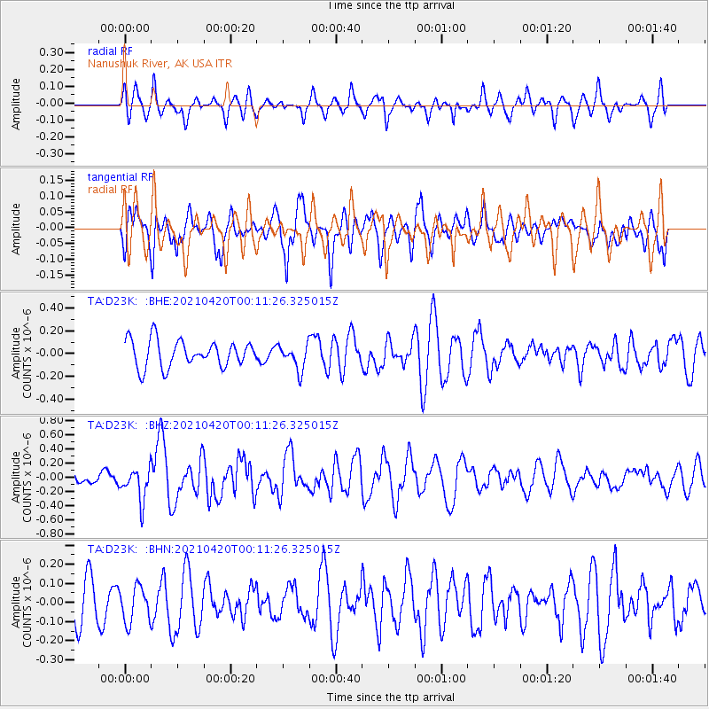
D23K Nanushuk River, AK USA - Earthquake Result Viewer
*The percent match for this event was below the threshold and hence no stack was calculated.
| Earthquake location: |
Off W Coast Of Northern Sumatra |
| Earthquake latitude/longitude: |
0.2/96.5 |
| Earthquake time(UTC): |
2021/04/19 (109) 23:58:22 GMT |
| Earthquake Depth: |
10 km |
| Earthquake Magnitude: |
6.0 mww |
| Earthquake Catalog/Contributor: |
NEIC PDE/us |
|
| Network: |
TA USArray Transportable Network (new EarthScope stations) |
| Station: |
D23K Nanushuk River, AK USA |
| Lat/Lon: |
68.97 N/150.68 W |
| Elevation: |
406 m |
|
| Distance: |
97.9 deg |
| Az: |
19.636 deg |
| Baz: |
291.446 deg |
| Ray Param: |
$rayparam |
*The percent match for this event was below the threshold and hence was not used in the summary stack. |
|
| Radial Match: |
53.35231 % |
| Radial Bump: |
361 |
| Transverse Match: |
57.241573 % |
| Transverse Bump: |
400 |
| SOD ConfigId: |
24334971 |
| Insert Time: |
2021-05-04 00:08:30.440 +0000 |
| GWidth: |
2.5 |
| Max Bumps: |
400 |
| Tol: |
0.001 |
|
Signal To Noise
| Channel | StoN | STA | LTA |
| TA:D23K: :BHZ:20210420T00:11:26.325015Z | 1.9558187 | 2.3007405E-7 | 1.1763568E-7 |
| TA:D23K: :BHN:20210420T00:11:26.325015Z | 0.86421984 | 9.4535636E-8 | 1.0938842E-7 |
| TA:D23K: :BHE:20210420T00:11:26.325015Z | 0.9649756 | 1.13034766E-7 | 1.1713743E-7 |
| Arrivals |
| Ps | |
| PpPs | |
| PsPs/PpSs | |


