You are here: Home > Network List > IW - Intermountain West Stations List
> Station RRI2 Red Ridge, Idaho, USA > Earthquake Result Viewer
RRI2 Red Ridge, Idaho, USA - Earthquake Result Viewer
| Earthquake location: |
South Of Panama |
| Earthquake latitude/longitude: |
5.0/-82.7 |
| Earthquake time(UTC): |
2008/06/17 (169) 17:42:09 GMT |
| Earthquake Depth: |
10 km |
| Earthquake Magnitude: |
5.6 MB, 5.3 MS, 5.9 MW, 5.9 MW |
| Earthquake Catalog/Contributor: |
WHDF/NEIC |
|
| Network: |
IW Intermountain West |
| Station: |
RRI2 Red Ridge, Idaho, USA |
| Lat/Lon: |
43.35 N/111.32 W |
| Elevation: |
2558 m |
|
| Distance: |
45.8 deg |
| Az: |
330.788 deg |
| Baz: |
138.204 deg |
| Ray Param: |
0.071030185 |
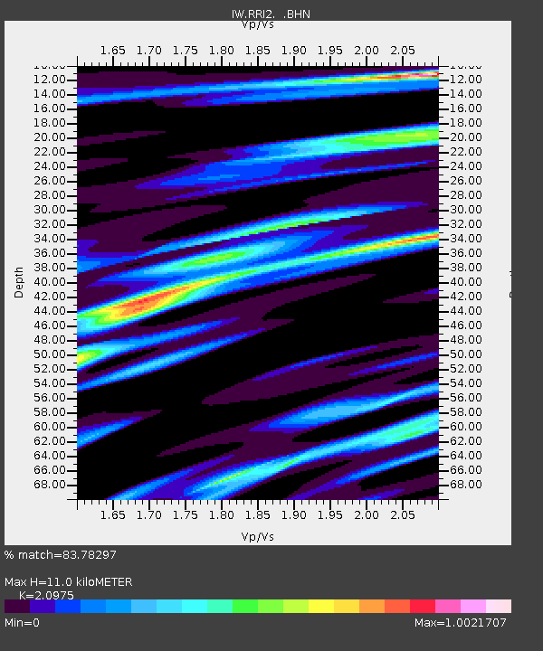
| Estimated Moho Depth: |
11.0 km |
| Estimated Crust Vp/Vs: |
2.10 |
| Assumed Crust Vp: |
6.207 km/s |
| Estimated Crust Vs: |
2.959 km/s |
| Estimated Crust Poisson's Ratio: |
0.35 |
|
| Radial Match: |
83.78297 % |
| Radial Bump: |
400 |
| Transverse Match: |
54.85354 % |
| Transverse Bump: |
400 |
| SOD ConfigId: |
2504 |
| Insert Time: |
2010-03-09 07:31:18.507 +0000 |
| GWidth: |
2.5 |
| Max Bumps: |
400 |
| Tol: |
0.001 |
|

Signal To Noise
| Channel | StoN | STA | LTA |
| IW:RRI2: :BHN:20080617T17:50:00.689989Z | 8.667311 | 5.777182E-7 | 6.665484E-8 |
| IW:RRI2: :BHE:20080617T17:50:00.689989Z | 3.4164734 | 3.2929594E-7 | 9.638476E-8 |
| IW:RRI2: :BHZ:20080617T17:50:00.689989Z | 3.1766605 | 2.6046303E-7 | 8.199272E-8 |
| Arrivals |
| Ps | 2.0 SECOND |
| PpPs | 5.2 SECOND |
| PsPs/PpSs | 7.3 SECOND |


