You are here: Home > Network List > AK - Alaska Regional Network Stations List
> Station CCB Clear Creek Butte > Earthquake Result Viewer
CCB Clear Creek Butte - Earthquake Result Viewer
| Earthquake location: |
Fiji Islands Region |
| Earthquake latitude/longitude: |
-18.9/-176.2 |
| Earthquake time(UTC): |
2021/04/24 (114) 00:23:36 GMT |
| Earthquake Depth: |
289 km |
| Earthquake Magnitude: |
6.4 Mww |
| Earthquake Catalog/Contributor: |
NEIC PDE/us |
|
| Network: |
AK Alaska Regional Network |
| Station: |
CCB Clear Creek Butte |
| Lat/Lon: |
64.65 N/147.80 W |
| Elevation: |
248 m |
|
| Distance: |
86.1 deg |
| Az: |
11.857 deg |
| Baz: |
206.856 deg |
| Ray Param: |
0.043555617 |
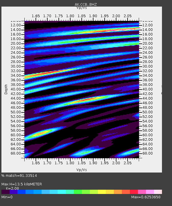
| Estimated Moho Depth: |
13.5 km |
| Estimated Crust Vp/Vs: |
2.08 |
| Assumed Crust Vp: |
6.566 km/s |
| Estimated Crust Vs: |
3.157 km/s |
| Estimated Crust Poisson's Ratio: |
0.35 |
|
| Radial Match: |
91.33514 % |
| Radial Bump: |
400 |
| Transverse Match: |
85.73246 % |
| Transverse Bump: |
369 |
| SOD ConfigId: |
24334971 |
| Insert Time: |
2021-05-08 00:27:14.776 +0000 |
| GWidth: |
2.5 |
| Max Bumps: |
400 |
| Tol: |
0.001 |
|

Signal To Noise
| Channel | StoN | STA | LTA |
| AK:CCB: :BHZ:20210424T00:35:14.128024Z | 46.95151 | 3.5892458E-6 | 7.64458E-8 |
| AK:CCB: :BHN:20210424T00:35:14.128024Z | 15.685985 | 1.0593521E-6 | 6.753495E-8 |
| AK:CCB: :BHE:20210424T00:35:14.128024Z | 10.06779 | 7.056362E-7 | 7.008849E-8 |
| Arrivals |
| Ps | 2.3 SECOND |
| PpPs | 6.2 SECOND |
| PsPs/PpSs | 8.5 SECOND |


