You are here: Home > Network List > AK - Alaska Regional Network Stations List
> Station PS08 TAPS Pump Station 8, AK, USA > Earthquake Result Viewer
PS08 TAPS Pump Station 8, AK, USA - Earthquake Result Viewer
| Earthquake location: |
Fiji Islands Region |
| Earthquake latitude/longitude: |
-18.9/-176.2 |
| Earthquake time(UTC): |
2021/04/24 (114) 00:23:36 GMT |
| Earthquake Depth: |
289 km |
| Earthquake Magnitude: |
6.4 Mww |
| Earthquake Catalog/Contributor: |
NEIC PDE/us |
|
| Network: |
AK Alaska Regional Network |
| Station: |
PS08 TAPS Pump Station 8, AK, USA |
| Lat/Lon: |
64.54 N/146.82 W |
| Elevation: |
320 m |
|
| Distance: |
86.2 deg |
| Az: |
12.282 deg |
| Baz: |
207.769 deg |
| Ray Param: |
0.043481845 |
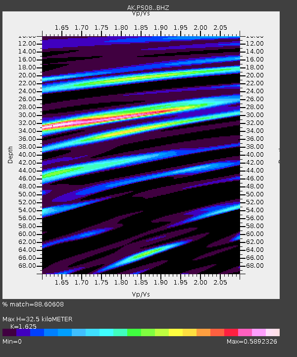
| Estimated Moho Depth: |
32.5 km |
| Estimated Crust Vp/Vs: |
1.62 |
| Assumed Crust Vp: |
6.566 km/s |
| Estimated Crust Vs: |
4.041 km/s |
| Estimated Crust Poisson's Ratio: |
0.20 |
|
| Radial Match: |
88.60608 % |
| Radial Bump: |
312 |
| Transverse Match: |
82.57867 % |
| Transverse Bump: |
400 |
| SOD ConfigId: |
24334971 |
| Insert Time: |
2021-05-08 00:29:49.260 +0000 |
| GWidth: |
2.5 |
| Max Bumps: |
400 |
| Tol: |
0.001 |
|

Signal To Noise
| Channel | StoN | STA | LTA |
| AK:PS08: :BHZ:20210424T00:35:14.628024Z | 41.640285 | 3.9103593E-6 | 9.390808E-8 |
| AK:PS08: :BHN:20210424T00:35:14.628024Z | 8.822731 | 1.1012132E-6 | 1.2481547E-7 |
| AK:PS08: :BHE:20210424T00:35:14.628024Z | 7.268954 | 8.3105294E-7 | 1.1432909E-7 |
| Arrivals |
| Ps | 3.2 SECOND |
| PpPs | 13 SECOND |
| PsPs/PpSs | 16 SECOND |


