You are here: Home > Network List > GS - US Geological Survey Networks Stations List
> Station DEC10 Finch Street Surface Site > Earthquake Result Viewer
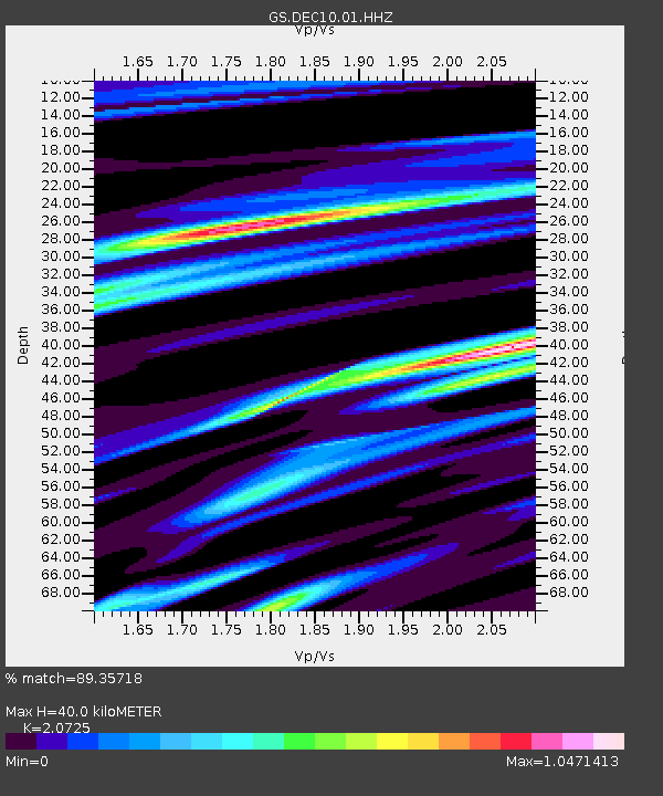
DEC10 Finch Street Surface Site - Earthquake Result Viewer
| Earthquake location: |
Costa Rica |
| Earthquake latitude/longitude: |
9.5/-84.5 |
| Earthquake time(UTC): |
2017/11/13 (317) 02:28:23 GMT |
| Earthquake Depth: |
19 km |
| Earthquake Magnitude: |
6.5 mww |
| Earthquake Catalog/Contributor: |
NEIC PDE/us |
|
| Network: |
GS US Geological Survey Networks |
| Station: |
DEC10 Finch Street Surface Site |
| Lat/Lon: |
39.89 N/88.92 W |
| Elevation: |
210 m |
|
| Distance: |
30.5 deg |
| Az: |
353.275 deg |
| Baz: |
171.365 deg |
| Ray Param: |
0.07930258 |
| Estimated Moho Depth: |
40.0 km |
| Estimated Crust Vp/Vs: |
2.07 |
| Assumed Crust Vp: |
6.444 km/s |
| Estimated Crust Vs: |
3.109 km/s |
| Estimated Crust Poisson's Ratio: |
0.35 |
|
| Radial Match: |
89.35718 % |
| Radial Bump: |
328 |
| Transverse Match: |
63.718 % |
| Transverse Bump: |
400 |
| SOD ConfigId: |
2429771 |
| Insert Time: |
2017-11-27 02:29:11.714 +0000 |
| GWidth: |
2.5 |
| Max Bumps: |
400 |
| Tol: |
0.001 |
|

Signal To Noise
| Channel | StoN | STA | LTA |
| GS:DEC10:01:HHZ:20171113T02:34:04.874Z | 16.698587 | 5.722E-6 | 3.4266372E-7 |
| GS:DEC10:01:HHN:20171113T02:34:04.874Z | 7.701655 | 3.3566544E-6 | 4.3583546E-7 |
| GS:DEC10:01:HHE:20171113T02:34:04.874Z | 1.5945609 | 7.602158E-7 | 4.7675562E-7 |
| Arrivals |
| Ps | 7.1 SECOND |
| PpPs | 18 SECOND |
| PsPs/PpSs | 25 SECOND |


