You are here: Home > Network List > GS - US Geological Survey Networks Stations List
> Station KS21 NEIC Portable/Temp deployment > Earthquake Result Viewer
KS21 NEIC Portable/Temp deployment - Earthquake Result Viewer
| Earthquake location: |
Costa Rica |
| Earthquake latitude/longitude: |
9.5/-84.5 |
| Earthquake time(UTC): |
2017/11/13 (317) 02:28:23 GMT |
| Earthquake Depth: |
19 km |
| Earthquake Magnitude: |
6.5 mww |
| Earthquake Catalog/Contributor: |
NEIC PDE/us |
|
| Network: |
GS US Geological Survey Networks |
| Station: |
KS21 NEIC Portable/Temp deployment |
| Lat/Lon: |
37.29 N/97.66 W |
| Elevation: |
414 m |
|
| Distance: |
30.1 deg |
| Az: |
338.749 deg |
| Baz: |
153.367 deg |
| Ray Param: |
0.07940761 |
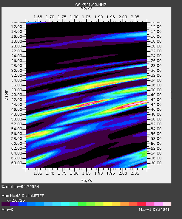
| Estimated Moho Depth: |
43.0 km |
| Estimated Crust Vp/Vs: |
2.07 |
| Assumed Crust Vp: |
6.483 km/s |
| Estimated Crust Vs: |
3.128 km/s |
| Estimated Crust Poisson's Ratio: |
0.35 |
|
| Radial Match: |
94.72554 % |
| Radial Bump: |
400 |
| Transverse Match: |
83.92757 % |
| Transverse Bump: |
400 |
| SOD ConfigId: |
2429771 |
| Insert Time: |
2017-11-27 02:29:28.197 +0000 |
| GWidth: |
2.5 |
| Max Bumps: |
400 |
| Tol: |
0.001 |
|

Signal To Noise
| Channel | StoN | STA | LTA |
| GS:KS21:00:HHZ:20171113T02:34:01.349006Z | 5.5222073 | 1.7932012E-6 | 3.2472545E-7 |
| GS:KS21:00:HH1:20171113T02:34:01.349006Z | 3.5907996 | 2.1778533E-6 | 6.065093E-7 |
| GS:KS21:00:HH2:20171113T02:34:01.349006Z | 1.9536223 | 9.637928E-7 | 4.933363E-7 |
| Arrivals |
| Ps | 7.6 SECOND |
| PpPs | 19 SECOND |
| PsPs/PpSs | 27 SECOND |


