You are here: Home > Network List > GT - Global Telemetered Seismograph Network (USAF/USGS) Stations List
> Station PLCA Paso Flores, Argentina > Earthquake Result Viewer
PLCA Paso Flores, Argentina - Earthquake Result Viewer

| Earthquake location: |
Costa Rica |
| Earthquake latitude/longitude: |
9.5/-84.5 |
| Earthquake time(UTC): |
2017/11/13 (317) 02:28:23 GMT |
| Earthquake Depth: |
19 km |
| Earthquake Magnitude: |
6.5 mww |
| Earthquake Catalog/Contributor: |
NEIC PDE/us |
|
| Network: |
GT Global Telemetered Seismograph Network (USAF/USGS) |
| Station: |
PLCA Paso Flores, Argentina |
| Lat/Lon: |
40.73 S/70.55 W |
| Elevation: |
1050 m |
|
| Distance: |
51.6 deg |
| Az: |
166.5 deg |
| Baz: |
342.361 deg |
| Ray Param: |
0.06726788 |
| Estimated Moho Depth: |
10.75 km |
| Estimated Crust Vp/Vs: |
2.07 |
| Assumed Crust Vp: |
6.597 km/s |
| Estimated Crust Vs: |
3.183 km/s |
| Estimated Crust Poisson's Ratio: |
0.35 |
|
| Radial Match: |
93.58146 % |
| Radial Bump: |
381 |
| Transverse Match: |
72.54552 % |
| Transverse Bump: |
400 |
| SOD ConfigId: |
2429771 |
| Insert Time: |
2017-11-27 02:29:32.125 +0000 |
| GWidth: |
2.5 |
| Max Bumps: |
400 |
| Tol: |
0.001 |
|
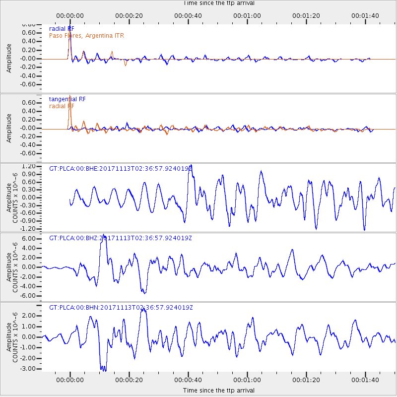
Signal To Noise
| Channel | StoN | STA | LTA |
| GT:PLCA:00:BHZ:20171113T02:36:57.924019Z | 3.949448 | 6.9826973E-7 | 1.7680185E-7 |
| GT:PLCA:00:BHN:20171113T02:36:57.924019Z | 4.665986 | 6.1140867E-7 | 1.3103525E-7 |
| GT:PLCA:00:BHE:20171113T02:36:57.924019Z | 1.2159775 | 2.9266212E-7 | 2.4068055E-7 |
| Arrivals |
| Ps | 1.8 SECOND |
| PpPs | 4.8 SECOND |
| PsPs/PpSs | 6.6 SECOND |


