You are here: Home > Network List > AZ - ANZA Regional Network Stations List
> Station SMER AZ.SMER > Earthquake Result Viewer
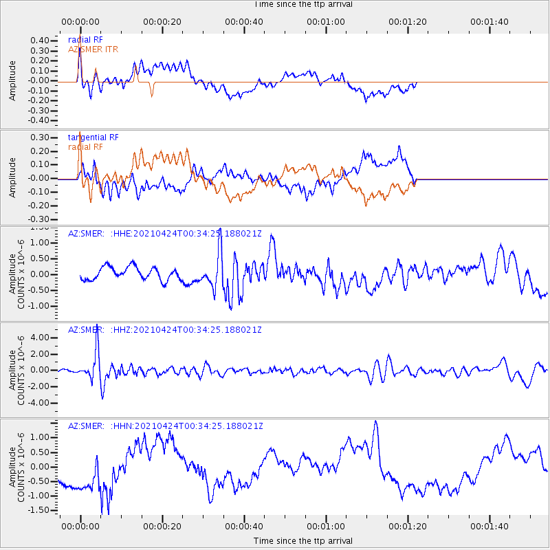
SMER AZ.SMER - Earthquake Result Viewer
*The percent match for this event was below the threshold and hence no stack was calculated.
| Earthquake location: |
Fiji Islands Region |
| Earthquake latitude/longitude: |
-18.9/-176.2 |
| Earthquake time(UTC): |
2021/04/24 (114) 00:23:36 GMT |
| Earthquake Depth: |
289 km |
| Earthquake Magnitude: |
6.4 Mww |
| Earthquake Catalog/Contributor: |
NEIC PDE/us |
|
| Network: |
AZ ANZA Regional Network |
| Station: |
SMER AZ.SMER |
| Lat/Lon: |
33.46 N/117.17 W |
| Elevation: |
355 m |
|
| Distance: |
76.7 deg |
| Az: |
47.461 deg |
| Baz: |
236.546 deg |
| Ray Param: |
$rayparam |
*The percent match for this event was below the threshold and hence was not used in the summary stack. |
|
| Radial Match: |
30.438555 % |
| Radial Bump: |
400 |
| Transverse Match: |
33.433006 % |
| Transverse Bump: |
400 |
| SOD ConfigId: |
24334971 |
| Insert Time: |
2021-05-08 00:34:29.372 +0000 |
| GWidth: |
2.5 |
| Max Bumps: |
400 |
| Tol: |
0.001 |
|
Signal To Noise
| Channel | StoN | STA | LTA |
| AZ:SMER: :HHZ:20210424T00:34:25.188021Z | 17.550493 | 1.7822634E-6 | 1.0155061E-7 |
| AZ:SMER: :HHN:20210424T00:34:25.188021Z | 2.4873466 | 7.737475E-7 | 3.1107348E-7 |
| AZ:SMER: :HHE:20210424T00:34:25.188021Z | 2.8925447 | 5.8192074E-7 | 2.0117952E-7 |
| Arrivals |
| Ps | |
| PpPs | |
| PsPs/PpSs | |


