You are here: Home > Network List > G - GEOSCOPE Stations List
> Station TAOE Taiohae, Marquises islands > Earthquake Result Viewer
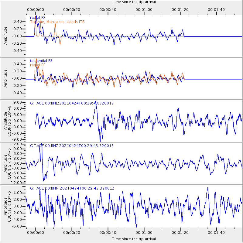
TAOE Taiohae, Marquises islands - Earthquake Result Viewer
*The percent match for this event was below the threshold and hence no stack was calculated.
| Earthquake location: |
Fiji Islands Region |
| Earthquake latitude/longitude: |
-18.9/-176.2 |
| Earthquake time(UTC): |
2021/04/24 (114) 00:23:36 GMT |
| Earthquake Depth: |
289 km |
| Earthquake Magnitude: |
6.4 Mww |
| Earthquake Catalog/Contributor: |
NEIC PDE/us |
|
| Network: |
G GEOSCOPE |
| Station: |
TAOE Taiohae, Marquises islands |
| Lat/Lon: |
8.85 S/140.15 W |
| Elevation: |
800 m |
|
| Distance: |
36.4 deg |
| Az: |
79.049 deg |
| Baz: |
250.128 deg |
| Ray Param: |
$rayparam |
*The percent match for this event was below the threshold and hence was not used in the summary stack. |
|
| Radial Match: |
75.31994 % |
| Radial Bump: |
400 |
| Transverse Match: |
57.669937 % |
| Transverse Bump: |
400 |
| SOD ConfigId: |
24334971 |
| Insert Time: |
2021-05-08 00:41:02.983 +0000 |
| GWidth: |
2.5 |
| Max Bumps: |
400 |
| Tol: |
0.001 |
|
Signal To Noise
| Channel | StoN | STA | LTA |
| G:TAOE:00:BHZ:20210424T00:29:43.32001Z | 2.9554813 | 5.740996E-6 | 1.942491E-6 |
| G:TAOE:00:BHN:20210424T00:29:43.32001Z | 1.0408931 | 1.8303483E-6 | 1.7584402E-6 |
| G:TAOE:00:BHE:20210424T00:29:43.32001Z | 2.9644558 | 4.1470184E-6 | 1.3989138E-6 |
| Arrivals |
| Ps | |
| PpPs | |
| PsPs/PpSs | |


