You are here: Home > Network List > IW - Intermountain West Stations List
> Station LOHW Long Hollow, Wyoming, USA > Earthquake Result Viewer
LOHW Long Hollow, Wyoming, USA - Earthquake Result Viewer
| Earthquake location: |
Costa Rica |
| Earthquake latitude/longitude: |
9.5/-84.5 |
| Earthquake time(UTC): |
2017/11/13 (317) 02:28:23 GMT |
| Earthquake Depth: |
19 km |
| Earthquake Magnitude: |
6.5 mww |
| Earthquake Catalog/Contributor: |
NEIC PDE/us |
|
| Network: |
IW Intermountain West |
| Station: |
LOHW Long Hollow, Wyoming, USA |
| Lat/Lon: |
43.61 N/110.60 W |
| Elevation: |
2121 m |
|
| Distance: |
40.9 deg |
| Az: |
330.749 deg |
| Baz: |
138.424 deg |
| Ray Param: |
0.07412011 |
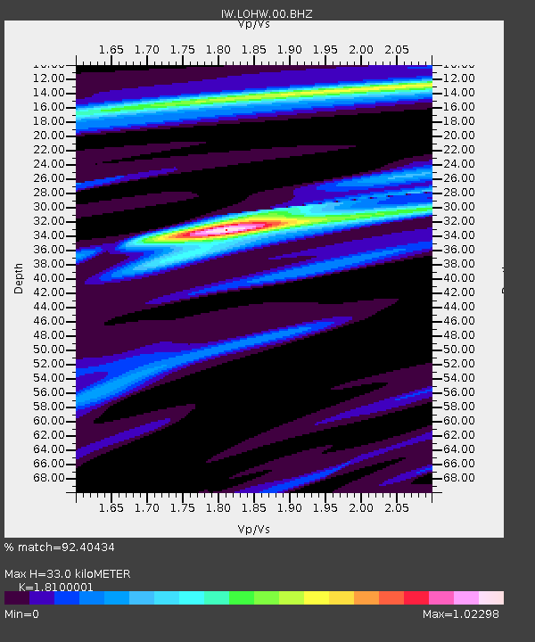
| Estimated Moho Depth: |
33.0 km |
| Estimated Crust Vp/Vs: |
1.81 |
| Assumed Crust Vp: |
6.207 km/s |
| Estimated Crust Vs: |
3.429 km/s |
| Estimated Crust Poisson's Ratio: |
0.28 |
|
| Radial Match: |
92.40434 % |
| Radial Bump: |
209 |
| Transverse Match: |
67.70764 % |
| Transverse Bump: |
400 |
| SOD ConfigId: |
2429771 |
| Insert Time: |
2017-11-27 02:30:14.794 +0000 |
| GWidth: |
2.5 |
| Max Bumps: |
400 |
| Tol: |
0.001 |
|

Signal To Noise
| Channel | StoN | STA | LTA |
| IW:LOHW:00:BHZ:20171113T02:35:33.509987Z | 14.539227 | 3.0233161E-6 | 2.0794202E-7 |
| IW:LOHW:00:BH1:20171113T02:35:33.509987Z | 5.6828556 | 1.4537806E-6 | 2.5581866E-7 |
| IW:LOHW:00:BH2:20171113T02:35:33.509987Z | 4.8388133 | 1.3646719E-6 | 2.8202615E-7 |
| Arrivals |
| Ps | 4.6 SECOND |
| PpPs | 14 SECOND |
| PsPs/PpSs | 19 SECOND |


