You are here: Home > Network List > IW - Intermountain West Stations List
> Station PLID Pearl Lake, Idaho, USA > Earthquake Result Viewer
PLID Pearl Lake, Idaho, USA - Earthquake Result Viewer
| Earthquake location: |
Costa Rica |
| Earthquake latitude/longitude: |
9.5/-84.5 |
| Earthquake time(UTC): |
2017/11/13 (317) 02:28:23 GMT |
| Earthquake Depth: |
19 km |
| Earthquake Magnitude: |
6.5 mww |
| Earthquake Catalog/Contributor: |
NEIC PDE/us |
|
| Network: |
IW Intermountain West |
| Station: |
PLID Pearl Lake, Idaho, USA |
| Lat/Lon: |
45.09 N/116.00 W |
| Elevation: |
2164 m |
|
| Distance: |
44.6 deg |
| Az: |
328.193 deg |
| Baz: |
132.785 deg |
| Ray Param: |
0.07177326 |
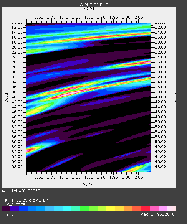
| Estimated Moho Depth: |
38.25 km |
| Estimated Crust Vp/Vs: |
1.78 |
| Assumed Crust Vp: |
6.571 km/s |
| Estimated Crust Vs: |
3.697 km/s |
| Estimated Crust Poisson's Ratio: |
0.27 |
|
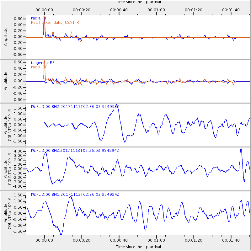
| Radial Match: |
91.89358 % |
| Radial Bump: |
312 |
| Transverse Match: |
57.68729 % |
| Transverse Bump: |
331 |
| SOD ConfigId: |
2429771 |
| Insert Time: |
2017-11-27 02:30:19.987 +0000 |
| GWidth: |
2.5 |
| Max Bumps: |
400 |
| Tol: |
0.001 |
|
Signal To Noise
| Channel | StoN | STA | LTA |
| IW:PLID:00:BHZ:20171113T02:36:03.954994Z | 10.992819 | 2.6866476E-6 | 2.4440024E-7 |
| IW:PLID:00:BH1:20171113T02:36:03.954994Z | 3.2972155 | 7.0428314E-7 | 2.1359938E-7 |
| IW:PLID:00:BH2:20171113T02:36:03.954994Z | 6.6521454 | 9.32176E-7 | 1.4013163E-7 |
| Arrivals |
| Ps | 4.8 SECOND |
| PpPs | 15 SECOND |
| PsPs/PpSs | 20 SECOND |


