You are here: Home > Network List > II - Global Seismograph Network (GSN - IRIS/IDA) Stations List
> Station XPFO Pinon Flat, California, USA > Earthquake Result Viewer
XPFO Pinon Flat, California, USA - Earthquake Result Viewer
*The percent match for this event was below the threshold and hence no stack was calculated.
| Earthquake location: |
Fiji Islands Region |
| Earthquake latitude/longitude: |
-18.9/-176.2 |
| Earthquake time(UTC): |
2021/04/24 (114) 00:23:36 GMT |
| Earthquake Depth: |
289 km |
| Earthquake Magnitude: |
6.4 Mww |
| Earthquake Catalog/Contributor: |
NEIC PDE/us |
|
| Network: |
II Global Seismograph Network (GSN - IRIS/IDA) |
| Station: |
XPFO Pinon Flat, California, USA |
| Lat/Lon: |
33.61 N/116.46 W |
| Elevation: |
1280 m |
|
| Distance: |
77.3 deg |
| Az: |
47.666 deg |
| Baz: |
236.986 deg |
| Ray Param: |
$rayparam |
*The percent match for this event was below the threshold and hence was not used in the summary stack. |
|
| Radial Match: |
78.114395 % |
| Radial Bump: |
229 |
| Transverse Match: |
63.257942 % |
| Transverse Bump: |
400 |
| SOD ConfigId: |
24334971 |
| Insert Time: |
2021-05-08 00:42:33.045 +0000 |
| GWidth: |
2.5 |
| Max Bumps: |
400 |
| Tol: |
0.001 |
|
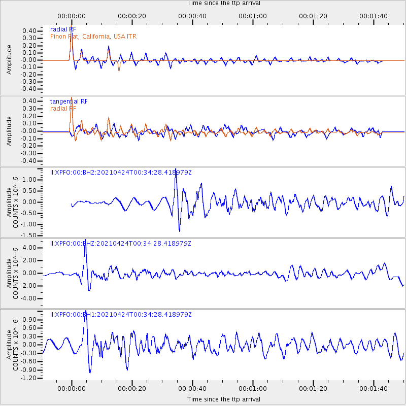
Signal To Noise
| Channel | StoN | STA | LTA |
| II:XPFO:00:BHZ:20210424T00:34:28.418979Z | 8.915608 | 1.7040757E-6 | 1.9113396E-7 |
| II:XPFO:00:BH1:20210424T00:34:28.418979Z | 3.2919016 | 4.8295504E-7 | 1.4671005E-7 |
| II:XPFO:00:BH2:20210424T00:34:28.418979Z | 4.1806316 | 5.0118524E-7 | 1.1988266E-7 |
| Arrivals |
| Ps | |
| PpPs | |
| PsPs/PpSs | |


