You are here: Home > Network List > NN - Western Great Basin/Eastern Sierra Nevada Stations List
> Station WAK Walker, California w84 > Earthquake Result Viewer
WAK Walker, California w84 - Earthquake Result Viewer
| Earthquake location: |
Fiji Islands Region |
| Earthquake latitude/longitude: |
-18.9/-176.2 |
| Earthquake time(UTC): |
2021/04/24 (114) 00:23:36 GMT |
| Earthquake Depth: |
289 km |
| Earthquake Magnitude: |
6.4 Mww |
| Earthquake Catalog/Contributor: |
NEIC PDE/us |
|
| Network: |
NN Western Great Basin/Eastern Sierra Nevada |
| Station: |
WAK Walker, California w84 |
| Lat/Lon: |
38.50 N/119.44 W |
| Elevation: |
1890 m |
|
| Distance: |
78.1 deg |
| Az: |
42.145 deg |
| Baz: |
234.057 deg |
| Ray Param: |
0.049128395 |
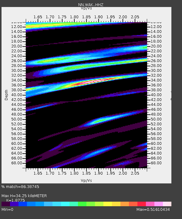
| Estimated Moho Depth: |
34.25 km |
| Estimated Crust Vp/Vs: |
1.88 |
| Assumed Crust Vp: |
6.279 km/s |
| Estimated Crust Vs: |
3.344 km/s |
| Estimated Crust Poisson's Ratio: |
0.30 |
|
| Radial Match: |
86.38745 % |
| Radial Bump: |
400 |
| Transverse Match: |
70.45161 % |
| Transverse Bump: |
400 |
| SOD ConfigId: |
24334971 |
| Insert Time: |
2021-05-08 00:44:59.797 +0000 |
| GWidth: |
2.5 |
| Max Bumps: |
400 |
| Tol: |
0.001 |
|

Signal To Noise
| Channel | StoN | STA | LTA |
| NN:WAK: :HHZ:20210424T00:34:32.634982Z | 23.586853 | 2.0548387E-6 | 8.711797E-8 |
| NN:WAK: :HHN:20210424T00:34:32.634982Z | 3.27934 | 3.2128528E-7 | 9.7972546E-8 |
| NN:WAK: :HHE:20210424T00:34:32.634982Z | 2.3753574 | 2.944142E-7 | 1.2394521E-7 |
| Arrivals |
| Ps | 4.9 SECOND |
| PpPs | 15 SECOND |
| PsPs/PpSs | 20 SECOND |


