You are here: Home > Network List > NN - Western Great Basin/Eastern Sierra Nevada Stations List
> Station MCM08 Monte Cristo Menlo 08 > Earthquake Result Viewer
MCM08 Monte Cristo Menlo 08 - Earthquake Result Viewer
| Earthquake location: |
Fiji Islands Region |
| Earthquake latitude/longitude: |
-18.9/-176.2 |
| Earthquake time(UTC): |
2021/04/24 (114) 00:23:36 GMT |
| Earthquake Depth: |
289 km |
| Earthquake Magnitude: |
6.4 Mww |
| Earthquake Catalog/Contributor: |
NEIC PDE/us |
|
| Network: |
NN Western Great Basin/Eastern Sierra Nevada |
| Station: |
MCM08 Monte Cristo Menlo 08 |
| Lat/Lon: |
38.16 N/118.05 W |
| Elevation: |
1669 m |
|
| Distance: |
78.7 deg |
| Az: |
43.076 deg |
| Baz: |
235.1 deg |
| Ray Param: |
0.04866512 |
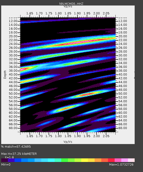
| Estimated Moho Depth: |
37.25 km |
| Estimated Crust Vp/Vs: |
1.60 |
| Assumed Crust Vp: |
6.279 km/s |
| Estimated Crust Vs: |
3.924 km/s |
| Estimated Crust Poisson's Ratio: |
0.18 |
|
| Radial Match: |
87.42695 % |
| Radial Bump: |
400 |
| Transverse Match: |
78.975266 % |
| Transverse Bump: |
400 |
| SOD ConfigId: |
24334971 |
| Insert Time: |
2021-05-08 00:45:09.026 +0000 |
| GWidth: |
2.5 |
| Max Bumps: |
400 |
| Tol: |
0.001 |
|

Signal To Noise
| Channel | StoN | STA | LTA |
| NN:MCM08: :HHZ:20210424T00:34:36.370028Z | 14.969701 | 1.9987967E-6 | 1.3352282E-7 |
| NN:MCM08: :HHN:20210424T00:34:36.370028Z | 2.7476873 | 3.5147696E-7 | 1.2791737E-7 |
| NN:MCM08: :HHE:20210424T00:34:36.370028Z | 7.816175 | 6.7582647E-7 | 8.6465114E-8 |
| Arrivals |
| Ps | 3.7 SECOND |
| PpPs | 15 SECOND |
| PsPs/PpSs | 19 SECOND |


