You are here: Home > Network List > IW - Intermountain West Stations List
> Station RWWY Rawlins, Wyoming, USA > Earthquake Result Viewer
RWWY Rawlins, Wyoming, USA - Earthquake Result Viewer
| Earthquake location: |
Volcano Islands, Japan Region |
| Earthquake latitude/longitude: |
22.0/142.7 |
| Earthquake time(UTC): |
2007/09/28 (271) 13:38:59 GMT |
| Earthquake Depth: |
276 km |
| Earthquake Magnitude: |
6.7 MB, 7.4 MW, 7.4 MW |
| Earthquake Catalog/Contributor: |
WHDF/NEIC |
|
| Network: |
IW Intermountain West |
| Station: |
RWWY Rawlins, Wyoming, USA |
| Lat/Lon: |
41.69 N/107.21 W |
| Elevation: |
2402 m |
|
| Distance: |
89.6 deg |
| Az: |
44.685 deg |
| Baz: |
299.388 deg |
| Ray Param: |
0.04167166 |
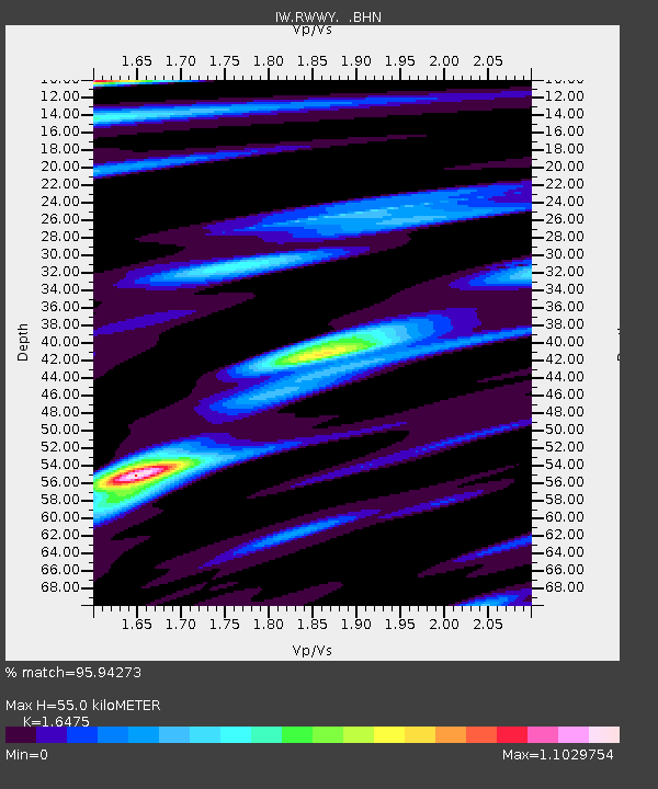
| Estimated Moho Depth: |
55.0 km |
| Estimated Crust Vp/Vs: |
1.65 |
| Assumed Crust Vp: |
6.159 km/s |
| Estimated Crust Vs: |
3.738 km/s |
| Estimated Crust Poisson's Ratio: |
0.21 |
|
| Radial Match: |
95.94273 % |
| Radial Bump: |
397 |
| Transverse Match: |
92.98123 % |
| Transverse Bump: |
400 |
| SOD ConfigId: |
2564 |
| Insert Time: |
2010-03-09 07:33:50.491 +0000 |
| GWidth: |
2.5 |
| Max Bumps: |
400 |
| Tol: |
0.001 |
|

Signal To Noise
| Channel | StoN | STA | LTA |
| IW:RWWY: :BHN:20070928T13:50:54.539014Z | 17.303896 | 2.1340193E-6 | 1.2332595E-7 |
| IW:RWWY: :BHE:20070928T13:50:54.539014Z | 20.02503 | 2.4636486E-6 | 1.2302844E-7 |
| IW:RWWY: :BHZ:20070928T13:50:54.539014Z | 72.11829 | 9.200987E-6 | 1.2758187E-7 |
| Arrivals |
| Ps | 5.9 SECOND |
| PpPs | 23 SECOND |
| PsPs/PpSs | 29 SECOND |


