You are here: Home > Network List > NE - New England Seismic Network Stations List
> Station HNH Hanover, NH, USA > Earthquake Result Viewer
HNH Hanover, NH, USA - Earthquake Result Viewer
| Earthquake location: |
Costa Rica |
| Earthquake latitude/longitude: |
9.5/-84.5 |
| Earthquake time(UTC): |
2017/11/13 (317) 02:28:23 GMT |
| Earthquake Depth: |
19 km |
| Earthquake Magnitude: |
6.5 mww |
| Earthquake Catalog/Contributor: |
NEIC PDE/us |
|
| Network: |
NE New England Seismic Network |
| Station: |
HNH Hanover, NH, USA |
| Lat/Lon: |
43.71 N/72.29 W |
| Elevation: |
180 m |
|
| Distance: |
35.7 deg |
| Az: |
15.234 deg |
| Baz: |
200.941 deg |
| Ray Param: |
0.07707028 |
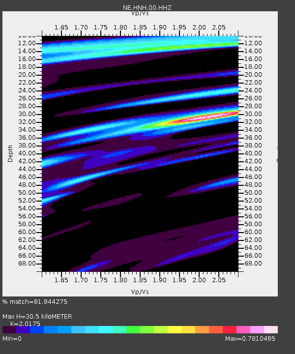
| Estimated Moho Depth: |
30.5 km |
| Estimated Crust Vp/Vs: |
2.02 |
| Assumed Crust Vp: |
6.419 km/s |
| Estimated Crust Vs: |
3.182 km/s |
| Estimated Crust Poisson's Ratio: |
0.34 |
|
| Radial Match: |
91.944275 % |
| Radial Bump: |
260 |
| Transverse Match: |
87.21656 % |
| Transverse Bump: |
274 |
| SOD ConfigId: |
2429771 |
| Insert Time: |
2017-11-27 02:30:36.044 +0000 |
| GWidth: |
2.5 |
| Max Bumps: |
400 |
| Tol: |
0.001 |
|

Signal To Noise
| Channel | StoN | STA | LTA |
| NE:HNH:00:HHZ:20171113T02:34:49.893989Z | 13.724733 | 5.308842E-6 | 3.8680838E-7 |
| NE:HNH:00:HH1:20171113T02:34:49.893989Z | 9.287343 | 3.4138736E-6 | 3.6758345E-7 |
| NE:HNH:00:HH2:20171113T02:34:49.893989Z | 2.166531 | 5.2889146E-7 | 2.4411904E-7 |
| Arrivals |
| Ps | 5.2 SECOND |
| PpPs | 13 SECOND |
| PsPs/PpSs | 19 SECOND |


