You are here: Home > Network List > IW - Intermountain West Stations List
> Station RWWY Rawlins, Wyoming, USA > Earthquake Result Viewer
RWWY Rawlins, Wyoming, USA - Earthquake Result Viewer
| Earthquake location: |
Andreanof Islands, Aleutian Is. |
| Earthquake latitude/longitude: |
51.9/-177.5 |
| Earthquake time(UTC): |
2008/05/02 (123) 01:33:37 GMT |
| Earthquake Depth: |
14 km |
| Earthquake Magnitude: |
6.3 MB, 6.8 MS, 6.6 MW, 6.6 MW |
| Earthquake Catalog/Contributor: |
WHDF/NEIC |
|
| Network: |
IW Intermountain West |
| Station: |
RWWY Rawlins, Wyoming, USA |
| Lat/Lon: |
41.69 N/107.21 W |
| Elevation: |
2402 m |
|
| Distance: |
47.4 deg |
| Az: |
73.196 deg |
| Baz: |
307.574 deg |
| Ray Param: |
0.06997173 |
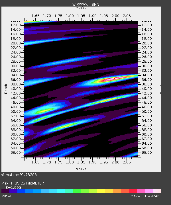
| Estimated Moho Depth: |
35.25 km |
| Estimated Crust Vp/Vs: |
2.00 |
| Assumed Crust Vp: |
6.159 km/s |
| Estimated Crust Vs: |
3.087 km/s |
| Estimated Crust Poisson's Ratio: |
0.33 |
|
| Radial Match: |
91.75293 % |
| Radial Bump: |
366 |
| Transverse Match: |
83.64814 % |
| Transverse Bump: |
400 |
| SOD ConfigId: |
2504 |
| Insert Time: |
2010-03-09 07:34:12.848 +0000 |
| GWidth: |
2.5 |
| Max Bumps: |
400 |
| Tol: |
0.001 |
|

Signal To Noise
| Channel | StoN | STA | LTA |
| IW:RWWY: :BHN:20080502T01:41:40.414011Z | 8.485943 | 1.3581197E-6 | 1.6004346E-7 |
| IW:RWWY: :BHE:20080502T01:41:40.414011Z | 2.1785069 | 3.8658465E-7 | 1.7745396E-7 |
| IW:RWWY: :BHZ:20080502T01:41:40.414011Z | 1.7889115 | 2.7442542E-7 | 1.5340358E-7 |
| Arrivals |
| Ps | 6.0 SECOND |
| PpPs | 16 SECOND |
| PsPs/PpSs | 22 SECOND |


