You are here: Home > Network List > IW - Intermountain West Stations List
> Station RWWY Rawlins, Wyoming, USA > Earthquake Result Viewer
RWWY Rawlins, Wyoming, USA - Earthquake Result Viewer
| Earthquake location: |
Solomon Islands |
| Earthquake latitude/longitude: |
-10.5/161.3 |
| Earthquake time(UTC): |
2008/06/03 (155) 16:20:50 GMT |
| Earthquake Depth: |
84 km |
| Earthquake Magnitude: |
6.2 MB, 6.2 MW, 6.2 MW |
| Earthquake Catalog/Contributor: |
WHDF/NEIC |
|
| Network: |
IW Intermountain West |
| Station: |
RWWY Rawlins, Wyoming, USA |
| Lat/Lon: |
41.69 N/107.21 W |
| Elevation: |
2402 m |
|
| Distance: |
98.0 deg |
| Az: |
49.123 deg |
| Baz: |
263.128 deg |
| Ray Param: |
0.039966345 |
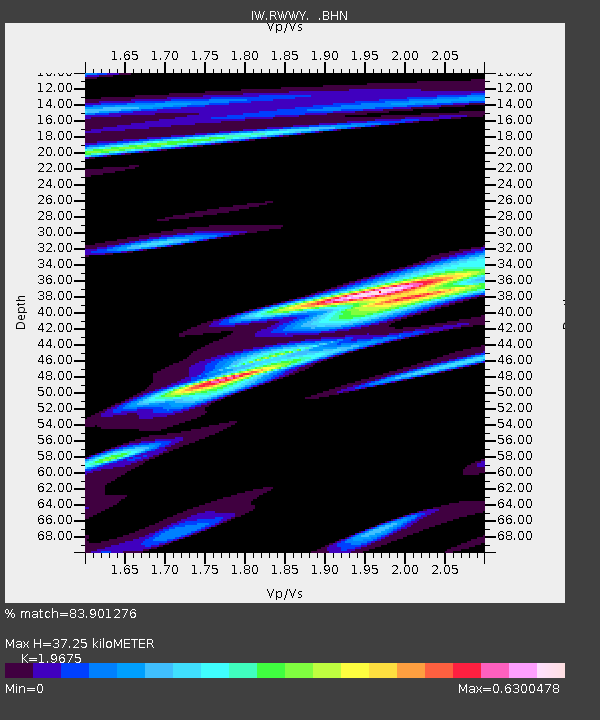
| Estimated Moho Depth: |
37.25 km |
| Estimated Crust Vp/Vs: |
1.97 |
| Assumed Crust Vp: |
6.159 km/s |
| Estimated Crust Vs: |
3.13 km/s |
| Estimated Crust Poisson's Ratio: |
0.33 |
|
| Radial Match: |
83.901276 % |
| Radial Bump: |
400 |
| Transverse Match: |
83.67059 % |
| Transverse Bump: |
364 |
| SOD ConfigId: |
2504 |
| Insert Time: |
2010-03-09 07:34:15.597 +0000 |
| GWidth: |
2.5 |
| Max Bumps: |
400 |
| Tol: |
0.001 |
|

Signal To Noise
| Channel | StoN | STA | LTA |
| IW:RWWY: :BHN:20080603T16:33:45.814021Z | 5.4304967 | 4.978854E-7 | 9.168322E-8 |
| IW:RWWY: :BHE:20080603T16:33:45.814021Z | 1.0797822 | 6.838204E-8 | 6.332947E-8 |
| IW:RWWY: :BHZ:20080603T16:33:45.814021Z | 2.343933 | 1.5756054E-7 | 6.7220576E-8 |
| Arrivals |
| Ps | 5.9 SECOND |
| PpPs | 18 SECOND |
| PsPs/PpSs | 24 SECOND |


