You are here: Home > Network List > NE - New England Seismic Network Stations List
> Station WVL Waterville, ME, USA > Earthquake Result Viewer
WVL Waterville, ME, USA - Earthquake Result Viewer
| Earthquake location: |
Costa Rica |
| Earthquake latitude/longitude: |
9.5/-84.5 |
| Earthquake time(UTC): |
2017/11/13 (317) 02:28:23 GMT |
| Earthquake Depth: |
19 km |
| Earthquake Magnitude: |
6.5 mww |
| Earthquake Catalog/Contributor: |
NEIC PDE/us |
|
| Network: |
NE New England Seismic Network |
| Station: |
WVL Waterville, ME, USA |
| Lat/Lon: |
44.56 N/69.66 W |
| Elevation: |
50 m |
|
| Distance: |
37.2 deg |
| Az: |
17.606 deg |
| Baz: |
204.671 deg |
| Ray Param: |
0.07624026 |
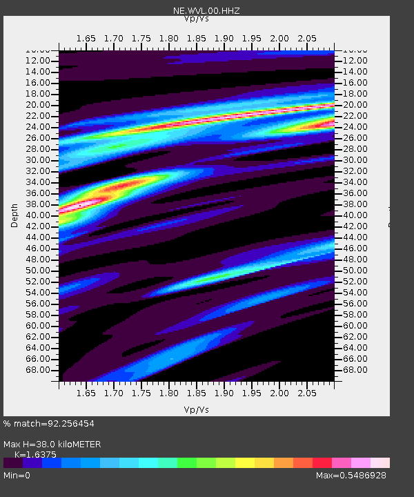
| Estimated Moho Depth: |
38.0 km |
| Estimated Crust Vp/Vs: |
1.64 |
| Assumed Crust Vp: |
6.419 km/s |
| Estimated Crust Vs: |
3.92 km/s |
| Estimated Crust Poisson's Ratio: |
0.20 |
|
| Radial Match: |
92.256454 % |
| Radial Bump: |
215 |
| Transverse Match: |
61.816326 % |
| Transverse Bump: |
400 |
| SOD ConfigId: |
2429771 |
| Insert Time: |
2017-11-27 02:30:44.925 +0000 |
| GWidth: |
2.5 |
| Max Bumps: |
400 |
| Tol: |
0.001 |
|

Signal To Noise
| Channel | StoN | STA | LTA |
| NE:WVL:00:HHZ:20171113T02:35:02.879005Z | 15.934997 | 6.3118778E-6 | 3.9610163E-7 |
| NE:WVL:00:HH1:20171113T02:35:02.879005Z | 8.547939 | 3.3239235E-6 | 3.8885668E-7 |
| NE:WVL:00:HH2:20171113T02:35:02.879005Z | 4.492089 | 2.1337125E-6 | 4.749934E-7 |
| Arrivals |
| Ps | 4.1 SECOND |
| PpPs | 14 SECOND |
| PsPs/PpSs | 19 SECOND |


