You are here: Home > Network List > PB - Plate Boundary Observatory Borehole Seismic Network Stations List
> Station B088 skyoks088bcs2007, Anza, CA, USA > Earthquake Result Viewer
B088 skyoks088bcs2007, Anza, CA, USA - Earthquake Result Viewer
| Earthquake location: |
Fiji Islands Region |
| Earthquake latitude/longitude: |
-18.9/-176.2 |
| Earthquake time(UTC): |
2021/04/24 (114) 00:23:36 GMT |
| Earthquake Depth: |
289 km |
| Earthquake Magnitude: |
6.4 Mww |
| Earthquake Catalog/Contributor: |
NEIC PDE/us |
|
| Network: |
PB Plate Boundary Observatory Borehole Seismic Network |
| Station: |
B088 skyoks088bcs2007, Anza, CA, USA |
| Lat/Lon: |
33.37 N/116.62 W |
| Elevation: |
1404 m |
|
| Distance: |
77.0 deg |
| Az: |
47.791 deg |
| Baz: |
236.923 deg |
| Ray Param: |
0.049808316 |
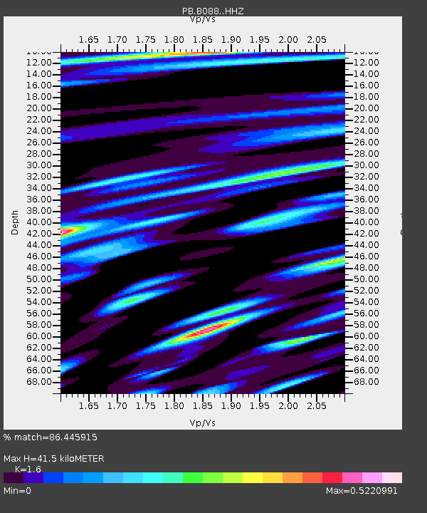
| Estimated Moho Depth: |
41.5 km |
| Estimated Crust Vp/Vs: |
1.60 |
| Assumed Crust Vp: |
6.264 km/s |
| Estimated Crust Vs: |
3.915 km/s |
| Estimated Crust Poisson's Ratio: |
0.18 |
|
| Radial Match: |
86.445915 % |
| Radial Bump: |
400 |
| Transverse Match: |
69.90429 % |
| Transverse Bump: |
400 |
| SOD ConfigId: |
24334971 |
| Insert Time: |
2021-05-08 00:47:51.289 +0000 |
| GWidth: |
2.5 |
| Max Bumps: |
400 |
| Tol: |
0.001 |
|

Signal To Noise
| Channel | StoN | STA | LTA |
| PB:B088: :HHZ:20210424T00:34:27.058993Z | 67.19295 | 1.7766224E-7 | 2.644061E-9 |
| PB:B088: :HH1:20210424T00:34:27.058993Z | 7.033127 | 1.42115155E-8 | 2.0206539E-9 |
| PB:B088: :HH2:20210424T00:34:27.058993Z | 6.626853 | 1.3903015E-8 | 2.0979816E-9 |
| Arrivals |
| Ps | 4.1 SECOND |
| PpPs | 17 SECOND |
| PsPs/PpSs | 21 SECOND |


