You are here: Home > Network List > IW - Intermountain West Stations List
> Station RWWY Rawlins, Wyoming, USA > Earthquake Result Viewer
RWWY Rawlins, Wyoming, USA - Earthquake Result Viewer
| Earthquake location: |
Sea Of Okhotsk |
| Earthquake latitude/longitude: |
53.9/152.9 |
| Earthquake time(UTC): |
2008/07/05 (187) 02:12:04 GMT |
| Earthquake Depth: |
633 km |
| Earthquake Magnitude: |
6.8 MB, 7.7 MW, 7.7 MW |
| Earthquake Catalog/Contributor: |
WHDF/NEIC |
|
| Network: |
IW Intermountain West |
| Station: |
RWWY Rawlins, Wyoming, USA |
| Lat/Lon: |
41.69 N/107.21 W |
| Elevation: |
2402 m |
|
| Distance: |
62.8 deg |
| Az: |
56.084 deg |
| Baz: |
319.007 deg |
| Ray Param: |
0.05753238 |
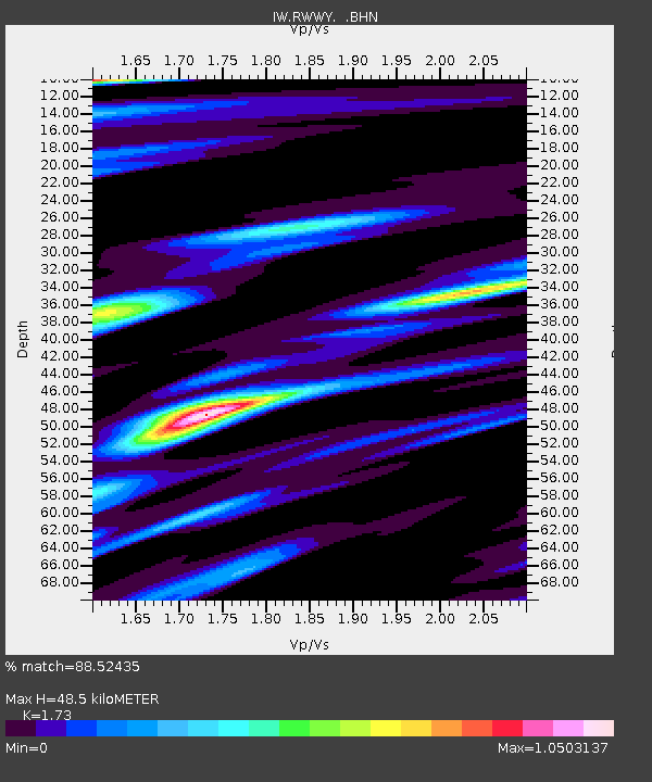
| Estimated Moho Depth: |
48.5 km |
| Estimated Crust Vp/Vs: |
1.73 |
| Assumed Crust Vp: |
6.159 km/s |
| Estimated Crust Vs: |
3.56 km/s |
| Estimated Crust Poisson's Ratio: |
0.25 |
|
| Radial Match: |
88.52435 % |
| Radial Bump: |
400 |
| Transverse Match: |
88.20138 % |
| Transverse Bump: |
400 |
| SOD ConfigId: |
2504 |
| Insert Time: |
2010-03-09 07:34:17.012 +0000 |
| GWidth: |
2.5 |
| Max Bumps: |
400 |
| Tol: |
0.001 |
|

Signal To Noise
| Channel | StoN | STA | LTA |
| IW:RWWY: :BHN:20080705T02:20:59.065022Z | 48.745113 | 6.298765E-6 | 1.2921839E-7 |
| IW:RWWY: :BHE:20080705T02:20:59.065022Z | 18.744112 | 1.904507E-6 | 1.0160562E-7 |
| IW:RWWY: :BHZ:20080705T02:20:59.065022Z | 7.78695 | 9.974503E-7 | 1.2809257E-7 |
| Arrivals |
| Ps | 6.0 SECOND |
| PpPs | 21 SECOND |
| PsPs/PpSs | 27 SECOND |


