You are here: Home > Network List > PY - PFO Array Stations List
> Station BPH10 Pinon Flat Observatory, CA, USA > Earthquake Result Viewer
BPH10 Pinon Flat Observatory, CA, USA - Earthquake Result Viewer
| Earthquake location: |
Fiji Islands Region |
| Earthquake latitude/longitude: |
-18.9/-176.2 |
| Earthquake time(UTC): |
2021/04/24 (114) 00:23:36 GMT |
| Earthquake Depth: |
289 km |
| Earthquake Magnitude: |
6.4 Mww |
| Earthquake Catalog/Contributor: |
NEIC PDE/us |
|
| Network: |
PY PFO Array |
| Station: |
BPH10 Pinon Flat Observatory, CA, USA |
| Lat/Lon: |
33.61 N/116.45 W |
| Elevation: |
1300 m |
|
| Distance: |
77.3 deg |
| Az: |
47.666 deg |
| Baz: |
236.988 deg |
| Ray Param: |
0.049638443 |
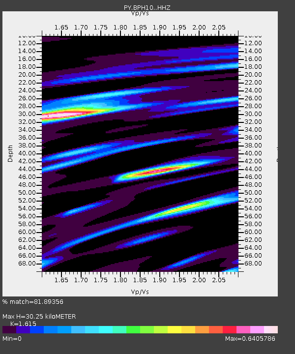
| Estimated Moho Depth: |
30.25 km |
| Estimated Crust Vp/Vs: |
1.62 |
| Assumed Crust Vp: |
6.264 km/s |
| Estimated Crust Vs: |
3.878 km/s |
| Estimated Crust Poisson's Ratio: |
0.19 |
|
| Radial Match: |
81.89356 % |
| Radial Bump: |
165 |
| Transverse Match: |
69.281555 % |
| Transverse Bump: |
400 |
| SOD ConfigId: |
24334971 |
| Insert Time: |
2021-05-08 00:48:20.457 +0000 |
| GWidth: |
2.5 |
| Max Bumps: |
400 |
| Tol: |
0.001 |
|

Signal To Noise
| Channel | StoN | STA | LTA |
| PY:BPH10: :HHZ:20210424T00:34:28.425998Z | 8.876286 | 1.6791575E-6 | 1.8917345E-7 |
| PY:BPH10: :HHN:20210424T00:34:28.425998Z | 3.0858963 | 4.7800563E-7 | 1.5490009E-7 |
| PY:BPH10: :HHE:20210424T00:34:28.425998Z | 3.9986885 | 4.876291E-7 | 1.2194727E-7 |
| Arrivals |
| Ps | 3.1 SECOND |
| PpPs | 12 SECOND |
| PsPs/PpSs | 15 SECOND |


