You are here: Home > Network List > PY - PFO Array Stations List
> Station BPH13 Pinon Flat Observatory, CA, USA > Earthquake Result Viewer
BPH13 Pinon Flat Observatory, CA, USA - Earthquake Result Viewer
| Earthquake location: |
Fiji Islands Region |
| Earthquake latitude/longitude: |
-18.9/-176.2 |
| Earthquake time(UTC): |
2021/04/24 (114) 00:23:36 GMT |
| Earthquake Depth: |
289 km |
| Earthquake Magnitude: |
6.4 Mww |
| Earthquake Catalog/Contributor: |
NEIC PDE/us |
|
| Network: |
PY PFO Array |
| Station: |
BPH13 Pinon Flat Observatory, CA, USA |
| Lat/Lon: |
33.61 N/116.46 W |
| Elevation: |
1300 m |
|
| Distance: |
77.3 deg |
| Az: |
47.665 deg |
| Baz: |
236.983 deg |
| Ray Param: |
0.049643546 |
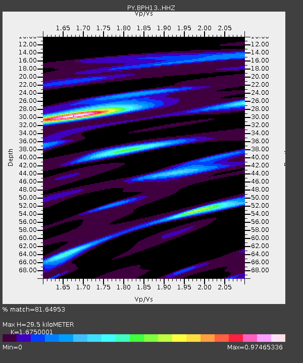
| Estimated Moho Depth: |
29.5 km |
| Estimated Crust Vp/Vs: |
1.68 |
| Assumed Crust Vp: |
6.264 km/s |
| Estimated Crust Vs: |
3.739 km/s |
| Estimated Crust Poisson's Ratio: |
0.22 |
|
| Radial Match: |
81.64953 % |
| Radial Bump: |
192 |
| Transverse Match: |
68.037636 % |
| Transverse Bump: |
400 |
| SOD ConfigId: |
24334971 |
| Insert Time: |
2021-05-08 00:48:25.359 +0000 |
| GWidth: |
2.5 |
| Max Bumps: |
400 |
| Tol: |
0.001 |
|

Signal To Noise
| Channel | StoN | STA | LTA |
| PY:BPH13: :HHZ:20210424T00:34:28.381015Z | 9.007423 | 1.6771992E-6 | 1.8620186E-7 |
| PY:BPH13: :HHN:20210424T00:34:28.381015Z | 3.4360933 | 4.6900774E-7 | 1.3649448E-7 |
| PY:BPH13: :HHE:20210424T00:34:28.381015Z | 4.1182 | 4.897719E-7 | 1.1892864E-7 |
| Arrivals |
| Ps | 3.3 SECOND |
| PpPs | 12 SECOND |
| PsPs/PpSs | 16 SECOND |


