You are here: Home > Network List > RV - Regional Alberta Seismic Observatory for Earthquake Studies Network Stations List
> Station YELLA Yellowhead Lookout Tower, AB > Earthquake Result Viewer
YELLA Yellowhead Lookout Tower, AB - Earthquake Result Viewer
| Earthquake location: |
Fiji Islands Region |
| Earthquake latitude/longitude: |
-18.9/-176.2 |
| Earthquake time(UTC): |
2021/04/24 (114) 00:23:36 GMT |
| Earthquake Depth: |
289 km |
| Earthquake Magnitude: |
6.4 Mww |
| Earthquake Catalog/Contributor: |
NEIC PDE/us |
|
| Network: |
RV Regional Alberta Seismic Observatory for Earthquake Studies Network |
| Station: |
YELLA Yellowhead Lookout Tower, AB |
| Lat/Lon: |
53.24 N/117.14 W |
| Elevation: |
1478 m |
|
| Distance: |
88.0 deg |
| Az: |
31.068 deg |
| Baz: |
234.362 deg |
| Ray Param: |
0.042197715 |
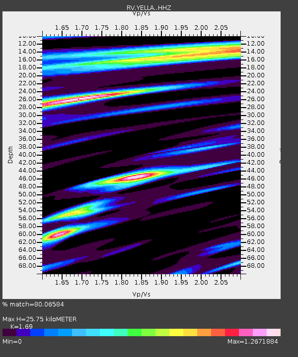
| Estimated Moho Depth: |
25.75 km |
| Estimated Crust Vp/Vs: |
1.69 |
| Assumed Crust Vp: |
6.142 km/s |
| Estimated Crust Vs: |
3.634 km/s |
| Estimated Crust Poisson's Ratio: |
0.23 |
|
| Radial Match: |
80.06584 % |
| Radial Bump: |
400 |
| Transverse Match: |
66.052185 % |
| Transverse Bump: |
400 |
| SOD ConfigId: |
24334971 |
| Insert Time: |
2021-05-08 00:49:03.805 +0000 |
| GWidth: |
2.5 |
| Max Bumps: |
400 |
| Tol: |
0.001 |
|

Signal To Noise
| Channel | StoN | STA | LTA |
| RV:YELLA: :HHZ:20210424T00:35:23.100009Z | 7.0607185 | 2.5298184E-6 | 3.5829476E-7 |
| RV:YELLA: :HHN:20210424T00:35:23.100009Z | 1.9787635 | 5.6422124E-7 | 2.851383E-7 |
| RV:YELLA: :HHE:20210424T00:35:23.100009Z | 2.1543858 | 6.9594654E-7 | 3.230371E-7 |
| Arrivals |
| Ps | 3.0 SECOND |
| PpPs | 11 SECOND |
| PsPs/PpSs | 14 SECOND |


