You are here: Home > Network List > TA - USArray Transportable Network (new EarthScope stations) Stations List
> Station D19K Kuna River, AK, USA > Earthquake Result Viewer
D19K Kuna River, AK, USA - Earthquake Result Viewer
| Earthquake location: |
Fiji Islands Region |
| Earthquake latitude/longitude: |
-18.9/-176.2 |
| Earthquake time(UTC): |
2021/04/24 (114) 00:23:36 GMT |
| Earthquake Depth: |
289 km |
| Earthquake Magnitude: |
6.4 Mww |
| Earthquake Catalog/Contributor: |
NEIC PDE/us |
|
| Network: |
TA USArray Transportable Network (new EarthScope stations) |
| Station: |
D19K Kuna River, AK, USA |
| Lat/Lon: |
68.49 N/158.12 W |
| Elevation: |
671 m |
|
| Distance: |
88.2 deg |
| Az: |
6.588 deg |
| Baz: |
197.132 deg |
| Ray Param: |
0.04209441 |
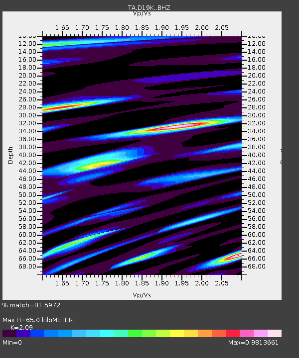
| Estimated Moho Depth: |
65.0 km |
| Estimated Crust Vp/Vs: |
2.09 |
| Assumed Crust Vp: |
6.221 km/s |
| Estimated Crust Vs: |
2.977 km/s |
| Estimated Crust Poisson's Ratio: |
0.35 |
|
| Radial Match: |
81.5972 % |
| Radial Bump: |
400 |
| Transverse Match: |
67.743256 % |
| Transverse Bump: |
400 |
| SOD ConfigId: |
24334971 |
| Insert Time: |
2021-05-08 00:49:56.886 +0000 |
| GWidth: |
2.5 |
| Max Bumps: |
400 |
| Tol: |
0.001 |
|

Signal To Noise
| Channel | StoN | STA | LTA |
| TA:D19K: :BHZ:20210424T00:35:23.774997Z | 36.22517 | 1.7289375E-6 | 4.772752E-8 |
| TA:D19K: :BHN:20210424T00:35:23.774997Z | 6.131411 | 4.6950527E-7 | 7.657378E-8 |
| TA:D19K: :BHE:20210424T00:35:23.774997Z | 2.5800834 | 1.5904544E-7 | 6.1643526E-8 |
| Arrivals |
| Ps | 12 SECOND |
| PpPs | 32 SECOND |
| PsPs/PpSs | 43 SECOND |


