You are here: Home > Network List > TA - USArray Transportable Network (new EarthScope stations) Stations List
> Station F24K Squaw Lake, AK, USA > Earthquake Result Viewer
F24K Squaw Lake, AK, USA - Earthquake Result Viewer
| Earthquake location: |
Fiji Islands Region |
| Earthquake latitude/longitude: |
-18.9/-176.2 |
| Earthquake time(UTC): |
2021/04/24 (114) 00:23:36 GMT |
| Earthquake Depth: |
289 km |
| Earthquake Magnitude: |
6.4 Mww |
| Earthquake Catalog/Contributor: |
NEIC PDE/us |
|
| Network: |
TA USArray Transportable Network (new EarthScope stations) |
| Station: |
F24K Squaw Lake, AK, USA |
| Lat/Lon: |
67.52 N/147.89 W |
| Elevation: |
736 m |
|
| Distance: |
88.7 deg |
| Az: |
10.525 deg |
| Baz: |
206.718 deg |
| Ray Param: |
0.04173321 |
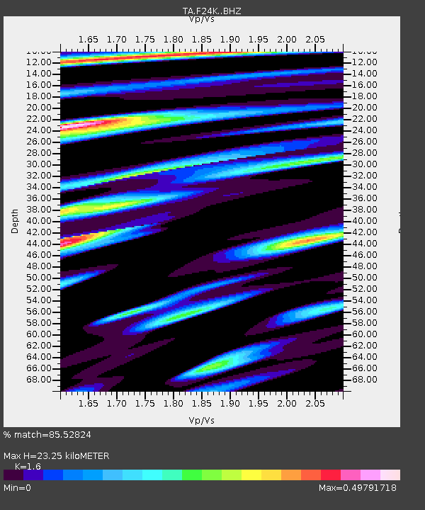
| Estimated Moho Depth: |
23.25 km |
| Estimated Crust Vp/Vs: |
1.60 |
| Assumed Crust Vp: |
6.522 km/s |
| Estimated Crust Vs: |
4.076 km/s |
| Estimated Crust Poisson's Ratio: |
0.18 |
|
| Radial Match: |
85.52824 % |
| Radial Bump: |
400 |
| Transverse Match: |
75.59063 % |
| Transverse Bump: |
400 |
| SOD ConfigId: |
24334971 |
| Insert Time: |
2021-05-08 00:50:14.699 +0000 |
| GWidth: |
2.5 |
| Max Bumps: |
400 |
| Tol: |
0.001 |
|
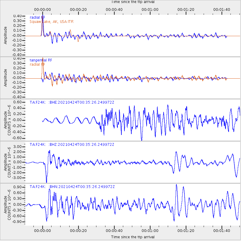
Signal To Noise
| Channel | StoN | STA | LTA |
| TA:F24K: :BHZ:20210424T00:35:26.249972Z | 22.333807 | 1.5321789E-6 | 6.860357E-8 |
| TA:F24K: :BHN:20210424T00:35:26.249972Z | 6.1170382 | 4.5557354E-7 | 7.447616E-8 |
| TA:F24K: :BHE:20210424T00:35:26.249972Z | 2.48326 | 1.7272957E-7 | 6.9557586E-8 |
| Arrivals |
| Ps | 2.2 SECOND |
| PpPs | 9.1 SECOND |
| PsPs/PpSs | 11 SECOND |


